Category:De Hilde (Havelte)
| Object location | | View all coordinates using: OpenStreetMap |
|---|
 | |||||
| Upload media | |||||
| Instance of | |||||
|---|---|---|---|---|---|
| Part of | |||||
| Location | Havelte, Drenthe, Netherlands | ||||
| Heritage designation |
| ||||
 | |||||
Nederlands: De Hilde
|
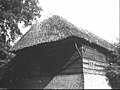
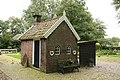
This is a category about rijksmonumentcomplex number 507518
|
Stookhut:
|
This is a category about rijksmonument number 507520 |
Schaapskooi:
|
This is a category about rijksmonument number 507521 |
| Address |
|
Media in category "De Hilde (Havelte)"
The following 16 files are in this category, out of 16 total.
-
 GRAANschuur PMVD F 42-5 - Havelte - 20484713 - RCE.jpg 1,200 × 900; 136 KB
-
 GRAANschuur PMVD F F 42-6 - Havelte - 20484714 - RCE.jpg 1,200 × 900; 147 KB
-
 Havelte 507519.jpg 3,888 × 2,592; 5.04 MB
-
 Havelte 507520.jpg 3,888 × 2,592; 5.84 MB
-
 Havelte 507521.jpg 3,888 × 2,592; 3.84 MB
-
 Kop- en zijgevel nr. F 497-34 - Havelte - 20493460 - RCE.jpg 1,200 × 900; 143 KB
-
 Linker zijgevel - Havelte - 20103606 - RCE.jpg 1,200 × 959; 329 KB
-
 Linker zijgevel - Havelte - 20103607 - RCE.jpg 1,200 × 955; 250 KB
-
 Overzicht - Havelte - 20103604 - RCE.jpg 1,200 × 959; 355 KB
-
 Rechter zijgevel schuur - Havelte - 20103609 - RCE.jpg 1,200 × 955; 301 KB
-
 Schuur, achtergevel - Havelte - 20103608 - RCE.jpg 1,200 × 951; 282 KB
-
 Schuurtje - Havelte - 20103610 - RCE.jpg 1,200 × 958; 385 KB
-
 Schuurtje - Havelte - 20103611 - RCE.jpg 1,200 × 953; 357 KB
-
 Voor- en zijgevel nr. F 497-35 - Havelte - 20493461 - RCE.jpg 1,200 × 900; 161 KB
-
 Voorgevel - Havelte - 20103605 - RCE.jpg 1,200 × 957; 393 KB
-
 Zij- en kopgevel nr. F 497-33 - Havelte - 20493459 - RCE.jpg 1,200 × 900; 129 KB


