Category:De Hoop, Den Hout
| Object location | | View all coordinates using: OpenStreetMap |
|---|
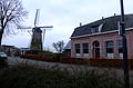
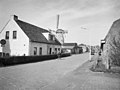
Nederlands: Afbeeldingen van de molen de Hoop, Ruiterspoor 8, 4911 BB Den Hout. Gelegen in Den Hout behorende tot de gemeente Oosterhout in de provincie Noord-Brabant in het zuiden van Nederland. Het is een rijksmonument
|
This is a category about rijksmonument number 31682
|
windmill in Den Hout, Netherlands  | |||||
| Upload media | |||||
| Instance of | |||||
|---|---|---|---|---|---|
| Location | Den Hout, Oosterhout, North Brabant, Netherlands | ||||
| Street address |
| ||||
| Located on street |
| ||||
| Has use | |||||
| Heritage designation |
| ||||
| Source of energy | |||||
 | |||||
Media in category "De Hoop, Den Hout"
The following 16 files are in this category, out of 16 total.
-
 Bergkorenmolen "De Hoop", gelegen voor een moestuin - Den Hout - 20053659 - RCE.jpg 1,200 × 1,195; 265 KB
-
 Close-up van wiekenkruis - Den Hout - 20117531 - RCE.jpg 1,200 × 1,174; 195 KB
-
 De Hoop (Den Hout) DSCF8547.jpg 1,864 × 2,816; 2.54 MB
-
 De Hoop, Den Hout DSCF8549.jpg 2,816 × 1,864; 2.51 MB
-
 Den Hout - molen De Hoop in omgeving.jpg 1,500 × 1,000; 702 KB
-
 Exterieur dorpsgezicht Ruiterspoor - Den Hout - 20000925 - RCE.jpg 1,200 × 896; 221 KB
-
 Herstelwerkzaamheden aan hekwerk van molenwiek - Den Hout - 20053660 - RCE.jpg 1,193 × 1,200; 244 KB
-
 P1020363Molen de Hoop.JPG 2,448 × 3,264; 3.33 MB
-

-

-

-

-
 Ronde stenen beltmolen van opzij gefotografeerd - Den Hout - 20117528 - RCE.jpg 1,200 × 1,185; 147 KB
-
 Ronde stenen beltmolen van voren gefotografeerd - Den Hout - 20117527 - RCE.jpg 1,200 × 1,192; 176 KB
-
 Ronde stenen beltmolen van voren gefotografeerd - Den Hout - 20117529 - RCE.jpg 1,200 × 1,181; 159 KB
-


_DSCF8547.jpg)


