Category:De Hoop, Oosteind
| Object location | | View all coordinates using: OpenStreetMap |
|---|
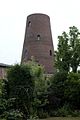
windmill in Oosteind, Netherlands  | |||||
| Upload media | |||||
| Instance of | |||||
|---|---|---|---|---|---|
| Location | Oosteind, Oosterhout, North Brabant, Netherlands | ||||
| Street address |
| ||||
| Located on street |
| ||||
| Has use | |||||
| Heritage designation |
| ||||
| Source of energy | |||||
 | |||||
|
This is a category about rijksmonument number 527663
|
| Address |
|
Media in category "De Hoop, Oosteind"
The following 5 files are in this category, out of 5 total.
-
 Ingang van voormalige koren- eekmolen - Oosteind - 20421321 - RCE.jpg 803 × 1,200; 171 KB
-
 P1040590 copyMolen.jpg 2,448 × 3,264; 2.3 MB
-
 Restant van voormalige koren- eekmolen - Oosteind - 20421319 - RCE.jpg 803 × 1,200; 109 KB
-
 Restant van voormalige koren- eekmolen - Oosteind - 20421320 - RCE.jpg 803 × 1,200; 205 KB
-
 Victoria - Oosteind - 20405077 - RCE.jpg 1,200 × 812; 291 KB


