Category:De Lankhorst (Diepenveen)
| Object location | | View all coordinates using: OpenStreetMap |
|---|
.jpg) | |||||
| Upload media | |||||
| Instance of | |||||
|---|---|---|---|---|---|
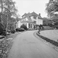
| Location | Diepenveen, Overijssel, Netherlands | ||||
| Street address |
| ||||
| Located on street |
| ||||
| Heritage designation |
| ||||
 | |||||
Nederlands: De Lankhorst
|
This is a category about rijksmonument number 508978
|
| Address |
|
Media in category "De Lankhorst (Diepenveen)"
The following 4 files are in this category, out of 4 total.
-
 Overzicht linker zijgevel villa - Diepenveen - 20351078 - RCE.jpg 1,188 × 1,200; 406 KB
-
 Overzicht voorgevel en linker zijgevel, villa - Diepenveen - 20351079 - RCE.jpg 1,200 × 1,195; 416 KB
-
 WLM - lbrt - Landhuis "De Lankhorst" (1).jpg 1,024 × 683; 399 KB
-
 WLM - lbrt - Landhuis "De Lankhorst".jpg 1,024 × 683; 449 KB


