Category:De Regt molen
| Object location | | View all coordinates using: OpenStreetMap |
|---|
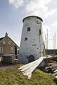
windmill in Nieuw-Lekkerland, Netherlands  | |||||
| Upload media | |||||
| Instance of |
| ||||
|---|---|---|---|---|---|
| Location | Nieuw-Lekkerland, South Holland, Netherlands | ||||
| Street address |
| ||||
| Located on street |
| ||||
| Has use | |||||
| Heritage designation |
| ||||
| Source of energy | |||||
 | |||||
|
This is a category about rijksmonument number 30537
|
| Address |
|
Media in category "De Regt molen"
The following 61 files are in this category, out of 61 total.
-
 Detail, nr 145 naast de deur - Nieuw-Lekkerland - 20421199 - RCE.jpg 1,200 × 800; 169 KB
-
 Detail, scheuren in de gevel - Nieuw-Lekkerland - 20421195 - RCE.jpg 1,200 × 800; 96 KB
-

-
 Detail, werkgerei - Nieuw-Lekkerland - 20421198 - RCE.jpg 1,200 × 800; 182 KB
-
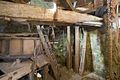
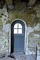 Interieur begane grond, overzicht deur - Nieuw-Lekkerland - 20428603 - RCE.jpg 800 × 1,200; 219 KB
-

-

-
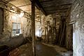
 Interieur bijgebouw, overzicht kelder - Nieuw-Lekkerland - 20428566 - RCE.jpg 1,200 × 800; 220 KB
-
 Interieur bijgebouw, overzicht kelder - Nieuw-Lekkerland - 20428567 - RCE.jpg 1,200 × 800; 203 KB
-
 Interieur bijgebouw, overzicht kelder - Nieuw-Lekkerland - 20428568 - RCE.jpg 1,200 × 800; 213 KB
-
 Interieur bijgebouw, overzicht kelder - Nieuw-Lekkerland - 20428578 - RCE.jpg 800 × 1,200; 215 KB
-
-
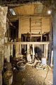 Interieur molen, overzicht kelder - Nieuw-Lekkerland - 20428558 - RCE.jpg 800 × 1,200; 246 KB
-
 Interieur, detail electra aansluiting - Nieuw-Lekkerland - 20428589 - RCE.jpg 800 × 1,200; 252 KB
-
 Interieur, detail maalstoel - Nieuw-Lekkerland - 20428595 - RCE.jpg 1,200 × 800; 212 KB
-
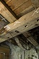
 Interieur, overzicht balklagen - Nieuw-Lekkerland - 20428601 - RCE.jpg 1,200 × 798; 174 KB
-
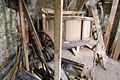
 Interieur, overzicht eerste verdieping - Nieuw-Lekkerland - 20428580 - RCE.jpg 1,200 × 800; 218 KB
-
 Interieur, overzicht eerste verdieping - Nieuw-Lekkerland - 20428581 - RCE.jpg 1,200 × 800; 238 KB
-
 Interieur, overzicht electra aansluiting - Nieuw-Lekkerland - 20428586 - RCE.jpg 800 × 1,200; 237 KB
-
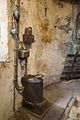
 Interieur, overzicht electromotor - Nieuw-Lekkerland - 20428597 - RCE.jpg 1,200 × 800; 171 KB
-

-

-

-
-
 Interieur, overzicht steenkraan - Nieuw-Lekkerland - 20428585 - RCE.jpg 800 × 1,200; 233 KB
-
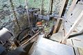
 Interieur, overzicht tweede verdieping - Nieuw-Lekkerland - 20428599 - RCE.jpg 1,200 × 800; 253 KB
-
 Interieur, overzicht tweede verdieping - Nieuw-Lekkerland - 20428600 - RCE.jpg 1,200 × 800; 239 KB
-
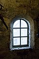
 Interieur, overzicht venster - Nieuw-Lekkerland - 20428608 - RCE.jpg 1,200 × 800; 172 KB
-
 Interieur, overzicht venster - Nieuw-Lekkerland - 20428609 - RCE.jpg 1,200 × 800; 143 KB
-
 Interieur, roeden in balklagen - Nieuw-Lekkerland - 20428606 - RCE.jpg 1,200 × 800; 181 KB
-
 Interieur, roeden in balklagen - Nieuw-Lekkerland - 20428607 - RCE.jpg 1,200 × 800; 217 KB
-
 Interieur, roeden verwerkt in balklagen - Nieuw-Lekkerland - 20428604 - RCE.jpg 800 × 1,200; 181 KB
-

-

-

-
 Korenmolen aan de Lekdijk, overzicht - Nieuw-Lekkerland - 20165348 - RCE.jpg 1,191 × 1,200; 282 KB
-
 Korenmolen de regt in nieuw-lekkerland (15) (16178423411).jpg 4,875 × 2,687; 1.79 MB
-
 Korenmolen de regt in nieuw-lekkerland (3) (15992886148).jpg 4,868 × 3,244; 5.21 MB
-
 Korenmolen de regt in nieuw-lekkerland (9) (15994236679).jpg 3,307 × 4,213; 3.76 MB
-
 Korenmolen in verval - Nieuw-Lekkerland - 20165346 - RCE.jpg 785 × 1,200; 148 KB
-
 Molen De Regt 1.jpg 4,896 × 3,672; 4.46 MB
-
 Molen De Regt 2.jpg 4,896 × 3,672; 5.14 MB
-
 Molen De Regt 3.jpg 4,896 × 3,672; 4.57 MB
-
 Nieuw Lekkerland De Regt 1870.JPG 2,288 × 1,712; 2.1 MB
-
 Nieuw-Lekkerland - molen De Regt 2014-03.JPG 1,200 × 944; 726 KB
-
 Nieuw-Lekkerland - Molen De Regt in restauratie 2010-12-25.jpg 1,600 × 1,600; 1.94 MB
-
 Overzicht betonnen baliedek - Nieuw-Lekkerland - 20428615 - RCE.jpg 1,200 × 800; 252 KB
-
 Overzicht betonnen baliedek - Nieuw-Lekkerland - 20428616 - RCE.jpg 1,200 × 800; 167 KB
-
 Overzicht molenromp - Nieuw-Lekkerland - 20428611 - RCE.jpg 800 × 1,200; 149 KB
-
 Overzicht molenromp - Nieuw-Lekkerland - 20428612 - RCE.jpg 800 × 1,200; 179 KB
-
 Overzicht molenromp - Nieuw-Lekkerland - 20428617 - RCE.jpg 800 × 1,200; 139 KB
-
 Overzicht molenromp met bijgebouw - Nieuw-Lekkerland - 20428610 - RCE.jpg 800 × 1,200; 150 KB
-
 Overzicht molenromp met bijgebouw - Nieuw-Lekkerland - 20428613 - RCE.jpg 1,200 × 800; 232 KB
-
 Overzicht van de achterzijde - Nieuw-Lekkerland - 20428618 - RCE.jpg 1,200 × 800; 261 KB
-
 Overzicht van de achterzijde - Nieuw-Lekkerland - 20428619 - RCE.jpg 1,200 × 800; 250 KB
-
 Overzicht van de achterzijde - Nieuw-Lekkerland - 20428620 - RCE.jpg 1,200 × 800; 228 KB
-
 Overzicht van de molen - Nieuw-Lekkerland - 20421200 - RCE.jpg 1,200 × 800; 204 KB
-
 Overzicht van de voorzijde - Nieuw-Lekkerland - 20421194 - RCE.jpg 800 × 1,200; 144 KB
-

-
 Panorama de regt, nieuw-lekkerlandJPG (16181038935).jpg 4,896 × 1,410; 1.66 MB
-
 Zicht op molenromp en bijgebouw - Nieuw-Lekkerland - 20428614 - RCE.jpg 800 × 1,200; 205 KB


_(16178423411).jpg)
_(15992886148).jpg)
_(15994236679).jpg)


.jpg)