Category:Denkmalzone Alter Friedhof (Haßloch)
![]()
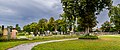
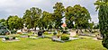
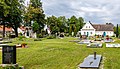
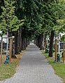
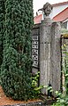
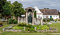
Monument zone old cemetery Haßloch
- Created in 1767, extended several times
- Enclosed on three sides by a wall
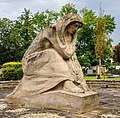
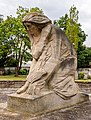
- Monumental war memorial 1870/71, 1914/18 und 1939/45, yellow sandstone, 1958 by Franz Lind, Freinsheim
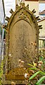
- Tombs:
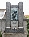
- Sauerbrunn family, Muschelkalk, 1920s by A. Jausel, Haßloch
- Schwarz-Münch family, neoclassical, 1930s
- Berrsche family, galvanic plastic, 1883 by Villeroy & Boch, Merzig
- E. Anicker († 1908), Art Nouveau, around 1910
- Brauch family, granite and galvanic relief, around 1910/20
- Adolf Trautwein (†1914), Muschelkalk
- Late baroque gravestone, 18th century
- Philipp H. Gutwein (†1833), late classicistic
- Chr. and Elisabetha Haß († 1854), late classicistic children's tomb
| Object location | | View all coordinates using: OpenStreetMap |
|---|
Media in category "Denkmalzone Alter Friedhof (Haßloch)"
The following 39 files are in this category, out of 39 total.
-
 Hassloch alter-friedhof grab-sauerbrunn 20120914 465e.jpg 4,000 × 3,000; 3.33 MB
-
 Haßloch Bahnhofstraße (Alter Friedhof) 001 2021 08 10.jpg 4,404 × 1,817; 3.64 MB
-
 Haßloch Bahnhofstraße (Alter Friedhof) 002 2021 08 10.jpg 4,458 × 1,795; 3.4 MB
-
 Haßloch Bahnhofstraße (Alter Friedhof) 003 2021 08 10.jpg 4,000 × 1,999; 2.56 MB
-
 Haßloch Bahnhofstraße (Alter Friedhof) 004 2021 08 10.jpg 4,149 × 1,927; 2.91 MB
-
 Haßloch Bahnhofstraße (Alter Friedhof) 005 2021 08 10.jpg 2,547 × 3,141; 3.18 MB
-
 Haßloch Bahnhofstraße (Alter Friedhof) 006 2021 08 10.jpg 3,673 × 2,178; 3.22 MB
-
 Haßloch Bahnhofstraße (Alter Friedhof) 007 2021 08 10.jpg 3,718 × 2,152; 3.19 MB
-
 Haßloch Bahnhofstraße (Alter Friedhof) 008 2021 08 10.jpg 3,378 × 4,340; 2.26 MB
-
 Haßloch Bahnhofstraße (Alter Friedhof) 009 2021 08 10.jpg 6,051 × 2,894; 3.72 MB
-
 Haßloch Bahnhofstraße (Alter Friedhof) 010 2021 08 10.jpg 2,326 × 3,439; 3.51 MB
-
 Haßloch Bahnhofstraße (Alter Friedhof) 011 2021 08 10.jpg 4,003 × 1,999; 2.47 MB
-
 Haßloch Bahnhofstraße (Alter Friedhof) 012 2021 08 10.jpg 2,433 × 3,288; 1.92 MB
-
 Haßloch Bahnhofstraße (Alter Friedhof) 013 2021 08 10.jpg 4,071 × 5,689; 4.7 MB
-
 Haßloch Bahnhofstraße (Alter Friedhof) 014 2021 08 10.jpg 2,854 × 2,802; 2.06 MB
-
 Haßloch Bahnhofstraße (Alter Friedhof) 015 2021 08 10.jpg 2,108 × 3,795; 2.31 MB
-
 Haßloch Bahnhofstraße (Alter Friedhof) 016 2021 08 10.jpg 3,983 × 5,264; 7.53 MB
-
 Haßloch Bahnhofstraße (Alter Friedhof) 017 2021 08 10.jpg 3,389 × 2,359; 2.78 MB
-
 Haßloch Bahnhofstraße (Alter Friedhof) 018 2021 08 10.jpg 2,497 × 3,203; 2.71 MB
-
 Haßloch Bahnhofstraße (Alter Friedhof) 019 2021 08 10.jpg 2,316 × 3,454; 2.36 MB
-
 Haßloch Bahnhofstraße (Alter Friedhof) 020 2021 08 10.jpg 2,310 × 3,462; 4.01 MB
-
 Haßloch Bahnhofstraße (Alter Friedhof) 021 2021 08 10.jpg 3,759 × 2,127; 2.33 MB
-
 Haßloch Bahnhofstraße (Alter Friedhof) 022 2021 08 10.jpg 3,197 × 2,502; 2.6 MB
-
 Haßloch Bahnhofstraße (Alter Friedhof) 023 2021 08 10.jpg 5,400 × 3,338; 3.53 MB
-
 Haßloch Bahnhofstraße (Alter Friedhof) 024 2021 08 10.jpg 3,991 × 4,988; 5.56 MB
-
 Haßloch Bahnhofstraße (Alter Friedhof) 025 2021 08 10.jpg 3,315 × 2,413; 3.49 MB
-
 Haßloch Bahnhofstraße (Alter Friedhof) 026 2021 08 10.jpg 3,654 × 5,503; 6.24 MB
-
 Haßloch Bahnhofstraße (Alter Friedhof) 027 2021 08 10.jpg 3,787 × 6,187; 8.42 MB
-
 Haßloch Bahnhofstraße (Alter Friedhof) 028 2021 08 10.jpg 3,272 × 5,397; 2.35 MB
-
 Haßloch Bahnhofstraße (Alter Friedhof) 029 2021 08 10.jpg 3,272 × 5,059; 2.6 MB
-
 Haßloch Bahnhofstraße (Alter Friedhof) 030 2021 08 10.jpg 4,471 × 3,474; 3.46 MB
-
 Haßloch Bahnhofstraße (Alter Friedhof) 031 2021 08 10.jpg 3,831 × 4,704; 3.21 MB
-
 Haßloch Bahnhofstraße (Alter Friedhof) 032 2021 08 10.jpg 5,784 × 3,367; 3.88 MB
-
 Haßloch Bahnhofstraße (Alter Friedhof) 033 2021 08 10.jpg 3,787 × 5,796; 3.59 MB
-
 Haßloch Bahnhofstraße (Alter Friedhof) 034 2021 08 10.jpg 3,490 × 2,292; 2.04 MB
-
 Haßloch Bahnhofstraße (Alter Friedhof) 035 2021 08 10.jpg 2,565 × 3,119; 2.31 MB
-
 Haßloch Bahnhofstraße (Alter Friedhof) 036 2021 08 10.jpg 3,547 × 6,115; 3.41 MB
-
 Haßloch Bahnhofstraße (Alter Friedhof) 037 2021 08 10.jpg 2,068 × 3,866; 2.76 MB
-
 Haßloch Bahnhofstraße (Alter Friedhof) 038 2021 08 10.jpg 2,135 × 3,748; 3.37 MB

_001_2021_08_10.jpg)
_003_2021_08_10.jpg)
_004_2021_08_10.jpg)
_005_2021_08_10.jpg)
_006_2021_08_10.jpg)
_007_2021_08_10.jpg)
_008_2021_08_10.jpg)
_009_2021_08_10.jpg)
_010_2021_08_10.jpg)
_011_2021_08_10.jpg)
_012_2021_08_10.jpg)
_013_2021_08_10.jpg)
_014_2021_08_10.jpg)
_015_2021_08_10.jpg)
_016_2021_08_10.jpg)
_017_2021_08_10.jpg)
_018_2021_08_10.jpg)
_019_2021_08_10.jpg)
_020_2021_08_10.jpg)
_021_2021_08_10.jpg)
_022_2021_08_10.jpg)
_023_2021_08_10.jpg)
_024_2021_08_10.jpg)
_025_2021_08_10.jpg)
_026_2021_08_10.jpg)
_027_2021_08_10.jpg)
_028_2021_08_10.jpg)
_029_2021_08_10.jpg)
_030_2021_08_10.jpg)
_031_2021_08_10.jpg)
_032_2021_08_10.jpg)
_033_2021_08_10.jpg)
_034_2021_08_10.jpg)
_035_2021_08_10.jpg)
_036_2021_08_10.jpg)
_037_2021_08_10.jpg)
_038_2021_08_10.jpg)
_002_2021_08_10.jpg)