Category:Depression rangefinders
fire control device | |||||
| Upload media | |||||
| Subclass of | |||||
|---|---|---|---|---|---|
| |||||
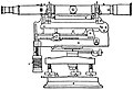
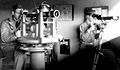
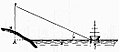
Depression range finder, a monoscopic single-view surveying instrument, used as a rangefinder. By using a surveyor's level with a graduated measure for elevation (in this case, depression) and by assuming the spherical nature of the Earth, this was a simple device which could measure range to a target, for the purpose of artillery. They required a level horizon out to the target, so could only be used on coasts looking out to sea. They were used for coastal defence artillery.
Media in category "Depression rangefinders"
The following 13 files are in this category, out of 13 total.
-
 Britannica Range-Finder, Depression.jpg 1,100 × 750; 179 KB
-
 Brockhaus and Efron Encyclopedic Dictionary b19 055-2.jpg 640 × 1,104; 36 KB
-
 Dentro de la Batería B-8 del Monte San Pedro - Un telémetro López Palomo (42265888790).jpg 3,000 × 2,000; 1.46 MB
-
 Depression position finder, Dover Castle.jpg 3,532 × 2,536; 2.53 MB
-
 DPF and Azimuth Scope.jpg 800 × 467; 87 KB
-
 DPF Angles-18.jpg 576 × 514; 31 KB
-
 Dunree Fort Rangefinder 2014 09 12.jpg 2,848 × 2,047; 3.96 MB
-
 East Side WW2 Plan.jpg 758 × 593; 173 KB
-
 Lauttasaari Länsiulapanniemi rangefinder tower.JPG 2,736 × 3,648; 3.98 MB
-
 MY0016-Area.jpg 563 × 750; 171 KB
-
 Warner-Swasey DPF.jpg 625 × 857; 236 KB
-

-


.jpg)


.jpg)
.jpg)