Category:Details of Sint Paulushofje
| NO WIKIDATA ID FOUND! Search for Details of Sint Paulushofje on Wikidata | |
| Upload media |
| Object location | | View all coordinates using: OpenStreetMap |
|---|
Nederlands: Afbeeldingen van details van het Sint Paulushofje, Markt 43 t/m 73, 4875 CC Etten-Leur. Gelegen in het centrum van Etten-Leur in de provincie Noord-Brabant in het zuiden van Nederland
|
This is a category about rijksmonument number 15396
|
Media in category "Details of Sint Paulushofje"
The following 5 files are in this category, out of 5 total.
-
 15396 Sint Paulushofje, Etten-Leur 003- detail ingang aan Markt 43 gevelsteen.JPG 2,592 × 1,944; 1.82 MB
-
 Exterieur GEDENKSTEEN, WAPENSTEEN - Etten - 20275185 - RCE.jpg 1,200 × 781; 180 KB
-
 Exterieur POMP, BEKRONING - Etten-Leur - 20275680 - RCE.jpg 788 × 1,200; 227 KB
-
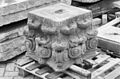 Exterieur POMP, BEKRONING - Etten-Leur - 20275681 - RCE.jpg 1,200 × 788; 235 KB
-
 Exterieur WAPENSTEEN - Etten - 20275186 - RCE.jpg 1,200 × 781; 178 KB


