Category:Dietkirche (Bonn)
| Object location | | View all coordinates using: OpenStreetMap |
|---|
| Upload media | |||||
| Instance of | |||||
|---|---|---|---|---|---|
| Location |
| ||||
 | |||||
Media in category "Dietkirche (Bonn)"
The following 26 files are in this category, out of 26 total.
-
-
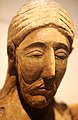
 2018 Rheinisches Landesmuseum Bonn, Dietkircher Christuskopf.jpg 1,912 × 2,798; 1.55 MB
-
 2018 Rheinisches Landesmuseum Bonn, Dietkircher Kruzifixus.jpg 1,999 × 2,753; 1.24 MB
-
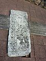
 Am Johanneskreuz Bonn. Info zum ehem. Marktgelände Dietkirchen.jpg 2,966 × 3,936; 8.26 MB
-
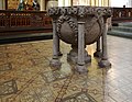 Basilika St. Johannes Baptist und Petrus in Bonn. Taufbecken aus Basaltlava (um 1290).jpg 4,932 × 3,828; 10.31 MB
-
 Bonn foundations Dietkirche.jpg 640 × 165; 91 KB
-
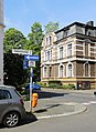 Bonn, Dietkirchenstraße.jpg 3,756 × 5,148; 10.82 MB
-
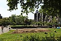 Bonn, Grünanlage innerh. des Siedl. Karrees Römerkastell (a).jpg 5,760 × 3,840; 11.36 MB
-
 Bonn, Grünanlage innerh. des Siedl. Karrees Römerkastell (b).jpg 4,032 × 3,024; 9.64 MB
-
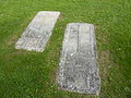
 Bonn-Castell, Grundrissrelief der abgegangenen Dietkirche.jpg 5,094 × 3,756; 8.95 MB
-
 Dietkirche (Bonn) (1).JPG 2,048 × 1,536; 368 KB
-
 Dietkirche (Bonn) (10).JPG 2,048 × 1,536; 1.52 MB
-
 Dietkirche (Bonn) (11).JPG 1,536 × 2,048; 1.15 MB
-
 Dietkirche (Bonn) (2).JPG 2,048 × 1,536; 1.53 MB
-
 Dietkirche (Bonn) (3).JPG 2,048 × 1,536; 1.59 MB
-
 Dietkirche (Bonn) (4).JPG 2,048 × 1,536; 1.58 MB
-
 Dietkirche (Bonn) (5).JPG 2,048 × 1,536; 1.62 MB
-
 Dietkirche (Bonn) (6).JPG 2,048 × 1,536; 1.48 MB
-
 Dietkirche (Bonn) (7).JPG 2,048 × 1,536; 1.59 MB
-
 Dietkirche (Bonn) (8).JPG 2,048 × 1,536; 1.52 MB
-
 Dietkirche (Bonn) (9).JPG 2,048 × 1,536; 1.59 MB
-
 Kruzifixus des 11. Jh., Kloster Dietkirchen. Ausstellung Rheinisches Landes Museum Bonn.jpg 2,848 × 4,272; 2.52 MB
-
 LVR-Landesmuseum Bonn, vermutlicher Kopf eines Christus 1015.jpg 3,456 × 4,929; 12.01 MB
-
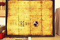 Urkunde HR II. 1015, (a) Pfarrarchiv der Stiftskirche Bonn.jpg 5,760 × 3,840; 10.03 MB
-
 Urkunde HR II. 1015, (b) Pfarrarchiv der Stiftskirche Bonn.jpg 3,564 × 2,842; 6.72 MB
-
 Zeichnung eines Grenzsteins des Stiftes Sankt Petrus in Dietkirchen (b)..jpg 1,298 × 1,904; 1.12 MB


.jpg)

.jpg)
.jpg)

_(1).JPG)
_(10).JPG)
_(11).JPG)
_(2).JPG)
_(3).JPG)
_(4).JPG)
_(5).JPG)
_(6).JPG)
_(7).JPG)
_(8).JPG)
_(9).JPG)


_Pfarrarchiv_der_Stiftskirche_Bonn.jpg)
_Pfarrarchiv_der_Stiftskirche_Bonn.jpg)
..jpg)