Category:Diolkos
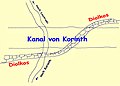
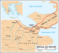
Deutsch: Der Diolkos war ein antiker griechischer Schiffkarrenweg, auf dem Schiffe über den Isthmus von Korinth transportiert wurden.
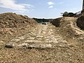
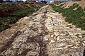
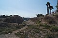
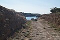
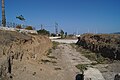
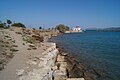
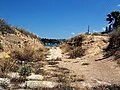
English: The Diolkos was a paved trackway in ancient Greece which enabled boats to be moved overland across the Isthmus of Corinth.
Français : Le Diolkos est l'ancienne piste pavée qui permettait à des bateaux de traverser l'isthme de Corinthe par voie de terre. Le diolkos a été utilisé pendant près de 7 siècles, de 600 avant J.-C. jusqu'au 1er siècle après J.-C.
paved trackway in Ancient Greece which enabled boats to be moved overland across the Isthmus of Corinth  | |||||
| Upload media | |||||
| Instance of | |||||
|---|---|---|---|---|---|
| Culture | |||||
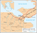
| Location | Isthmus of Corinth, Corinthia, Peloponnese Region, Decentralized Administration of Peloponnese, Western Greece and the Ionian Islands, Greece | ||||
 | |||||
Media in category "Diolkos"
The following 35 files are in this category, out of 35 total.
-
 Acient diolkos.jpg 3,072 × 2,304; 2.62 MB
-
 Canal de corinthe - chemin de halage.jpg 2,048 × 1,536; 1.42 MB
-
 Corinth ast 2005129 lrg.jpg 3,000 × 3,000; 2.76 MB
-
 Corinth, Greece (NASA).jpg 2,514 × 1,686; 7.43 MB
-
 Diolkos 01.jpg 4,032 × 3,024; 7.64 MB
-
 Diolkos 02.jpg 4,032 × 3,024; 6.39 MB
-
 Diolkos 1990 01.jpg 3,880 × 2,550; 3.13 MB
-
 Diolkos 1990 02.jpg 3,244 × 2,065; 1.89 MB
-
 Diolkos 1990 03.jpg 3,549 × 2,255; 2.55 MB
-
 Diolkos 1990 04.jpg 3,860 × 2,549; 2.73 MB
-
 Diolkos near Poseidonia 01.JPG 5,456 × 3,632; 5.97 MB
-
 Diolkos near Poseidonia 02.JPG 5,456 × 3,632; 5.31 MB
-
 Diolkos near Poseidonia 03.JPG 5,456 × 3,632; 5.63 MB
-
 Diolkos near Poseidonia 04.JPG 5,456 × 3,632; 5.81 MB
-
 Diolkos near Poseidonia 05.JPG 5,456 × 3,632; 5.84 MB
-
 Diolkos near Poseidonia 06.JPG 5,456 × 3,632; 7.63 MB
-
 Diolkos near Poseidonia 07.JPG 5,456 × 3,632; 8.28 MB
-
 Diolkos near Poseidonia 08.JPG 5,456 × 3,632; 7.41 MB
-
 Diolkos near Poseidonia 09.JPG 5,456 × 3,632; 9.38 MB
-
 Diolkos, Western End. Pic 01.jpg 1,536 × 2,048; 1.37 MB
-
 Diolkos, Western End. Pic 02.jpg 1,536 × 2,048; 1.1 MB
-
 Diolkos, Western End. Pic 03.jpg 2,048 × 1,536; 1.54 MB
-
 Diolkos, Western End. Pic 04.jpg 1,536 × 2,048; 1.67 MB
-
 Diolkos-1.jpg 985 × 709; 76 KB
-
 Diolkos1.jpg 580 × 768; 286 KB
-
 Diolkos2.jpg 1,400 × 1,050; 653 KB
-
 Isthme Corinthe fr.png 670 × 600; 185 KB
-
 Korinth Isthmus de.png 1,219 × 1,091; 196 KB
-
 Korinth Isthmus de.svg 585 × 524; 105 KB
-
 Remains of Nero's Isthmus Canal in 1881 (cropped).jpg 1,191 × 487; 201 KB
-
 Remains of Nero's Isthmus Canal in 1881.jpg 1,200 × 760; 225 KB
-
 Remains of the ancient diolkos of Corinth on 22 May 2019.jpg 6,000 × 4,000; 10.56 MB
-
 Remains of the Ancient Diolkos on the Isthmus of Corinth, 22 May 2019.jpg 6,000 × 4,000; 8.52 MB
-
 The excavated Ancient Diolkos on the Isthmus of Corinth on 22 May 2019.jpg 6,000 × 4,000; 8.26 MB
-
 Vestige de diolkos.JPG 2,304 × 1,728; 3.37 MB


.jpg)


.jpg)