Category:Dodd, Underskiddaw
English: Dodd is a hill in the civil parish of Underskiddaw, in the Allerdale district, in the county of Cumbria, England.
mountain in United Kingdom  | |||||
| Upload media | |||||
| Instance of | |||||
|---|---|---|---|---|---|
| Location | Cumbria, North West England, England | ||||
| Mountain range | |||||
| Elevation above sea level |
| ||||
| Parent peak | |||||
 | |||||
Media in category "Dodd, Underskiddaw"
The following 18 files are in this category, out of 18 total.
-
 Bass Lake from Dodd.jpg 1,503 × 1,058; 98 KB
-
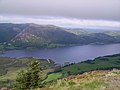 Bassenthwaite Lake from Dodd - geograph.org.uk - 654020.jpg 640 × 480; 61 KB
-
 Carl Side from Dodd - geograph.org.uk - 1070340.jpg 640 × 480; 85 KB
-
 Descending Dodd - geograph.org.uk - 1772620.jpg 640 × 480; 71 KB
-
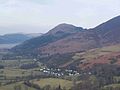 Dodd from near Keswick.jpg 2,304 × 1,728; 100 KB
-
 Dodd Summit - geograph.org.uk - 1511734.jpg 640 × 480; 74 KB
-
 Dodd Summit - geograph.org.uk - 490488.jpg 480 × 640; 116 KB
-
 Dodd viewed from Longside Edge - geograph.org.uk - 943613.jpg 640 × 426; 93 KB
-
 Frogspawn on Dodd - geograph.org.uk - 1772622.jpg 480 × 640; 143 KB
-
 From Dodd - geograph.org.uk - 1070705.jpg 640 × 480; 49 KB
-
 From Dodd - geograph.org.uk - 1771139.jpg 640 × 480; 60 KB
-
 Memorial ,Dodd Summit - geograph.org.uk - 654019.jpg 480 × 640; 82 KB
-
 North Western Fells from Dodd - geograph.org.uk - 1070339.jpg 640 × 480; 66 KB
-
 On Dodd - geograph.org.uk - 1070717.jpg 640 × 480; 85 KB
-
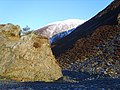 Rock, Heather and Snow - geograph.org.uk - 1070708.jpg 640 × 480; 102 KB
-
 Rotting Stump - geograph.org.uk - 1772619.jpg 480 × 640; 77 KB
-
 Seat on Dodd - geograph.org.uk - 1771105.jpg 640 × 466; 55 KB
-
 Slopes of Dodd - geograph.org.uk - 1771112.jpg 640 × 480; 57 KB


