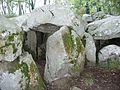
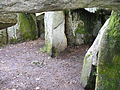
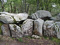
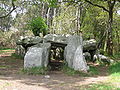
Category:Dolmen de Mané-Groh
|
This building is classé au titre des monuments historiques de la France. It is indexed in the base Mérimée, a database of architectural heritage maintained by the French Ministry of Culture, under the reference PA00091185
|
| Object location | | View all coordinates using: OpenStreetMap |
|---|
dolmen in Erdeven, France  | |||||
| Upload media | |||||
| Instance of | |||||
|---|---|---|---|---|---|
| Location | Erdeven, canton of Belz | ||||
| Street address |
| ||||
| Heritage designation |
| ||||
 | |||||
Media in category "Dolmen de Mané-Groh"
The following 25 files are in this category, out of 25 total.
-
 4763.Dolmen - GangGrab von Crucuno - Departement Morbihan - Bretagne Steffen Heilfort.JPG 2,560 × 1,920; 2.19 MB
-
 4764.Dolmen - GangGrab von Crucuno - Departement Morbihan - Bretagne Steffen Heilfort.JPG 2,560 × 1,920; 2.29 MB
-
 4765.Dolmen - GangGrab von Crucuno - Departement Morbihan - Bretagne Steffen Heilfort.JPG 2,560 × 1,920; 2.36 MB
-
 4766.Dolmen - GangGrab von Crucuno - Departement Morbihan - Bretagne Steffen Heilfort.JPG 2,560 × 1,920; 2.38 MB
-
 4767.Dolmen - GangGrab von Crucuno - Departement Morbihan - Bretagne Steffen Heilfort.JPG 2,560 × 1,920; 2.43 MB
-
 4768. Dolmen - GangGrab von Crucuno - Departement Morbihan - Bretagne Steffen Heilfort.JPG 2,560 × 1,920; 2.31 MB
-
 4769. Dolmen - GangGrab von Crucuno - Departement Morbihan - Bretagne Steffen Heilfort.JPG 2,560 × 1,920; 2.39 MB
-
 4770. Dolmen - GangGrab von Crucuno - Departement Morbihan - Bretagne Steffen Heilfort.JPG 2,560 × 1,920; 2.18 MB
-
 4771. Dolmen - GangGrab von Crucuno - Departement Morbihan - Bretagne Steffen Heilfort.JPG 2,560 × 1,920; 2.35 MB
-

-

-
-

-

-

-

-
-

-

-
 Dolmen du mané croch ou mané groh.jpg 1,890 × 833; 2.23 MB
-
 Dolmen du mané croch.jpg 1,890 × 833; 2.36 MB
-
 Mane Groh bei Plouharnel 1.jpg 2,048 × 1,536; 2.53 MB
-
 Mane Groh bei Plouharnel 2.jpg 2,048 × 1,536; 2.78 MB
-
 Plouharnel Crucuno Mieusement.jpg 5,295 × 3,875; 2.68 MB
-
 Woman near dolmen, Crucuno, Dept Morbihan, Bretagne.jpg 2,560 × 1,920; 2.38 MB


_Auf_aufgerichteten_Tragsteinen_liegende_grosse_Steinplatten_bezeichnet_man_als_Dolmen_-_GangGrab_von_Crucuno_-_Departement_Morbihan_-_Bretagne_Steffen_Heilfort.JPG)
_Auf_aufgerichteten_Tragsteinen_liegende_grosse_Steinplatten_bezeichnet_man_als_Dolmen_-_GangGrab_von_Crucuno_-_Departement_Morbihan_-_Bretagne_Steffen_Heilfort.JPG)
_Auf_aufgerichteten_Tragsteinen_liegende_grosse_Steinplatten_bezeichnet_man_als_Dolmen_-_GangGrab_von_Crucuno_-_Departement_Morbihan_-_Bretagne_Steffen_Heilfort.JPG)
_Auf_aufgerichteten_Tragsteinen_liegende_grosse_Steinplatten_bezeichnet_man_als_Dolmen_-_GangGrab_von_Crucuno_-_Departement_Morbihan_-_Bretagne_Steffen_Heilfort.JPG)
_Auf_aufgerichteten_Tragsteinen_liegende_grosse_Steinplatten_bezeichnet_man_als_Dolmen_-_GangGrab_von_Crucuno_-_Departement_Morbihan_-_Bretagne_Steffen_Heilfort.JPG)
_Auf_aufgerichteten_Tragsteinen_liegende_grosse_Steinplatten_bezeichnet_man_als_Dolmen_-_GangGrab_von_Crucuno_-_Departement_Morbihan_-_Bretagne_Steffen_Heilfort.JPG)
_Auf_aufgerichteten_Tragsteinen_liegende_grosse_Steinplatten_bezeichnet_man_als_Dolmen_-_GangGrab_von_Crucuno_-_Departement_Morbihan_-_Bretagne_Steffen_Heilfort.JPG)
_Auf_aufgerichteten_Tragsteinen_liegende_grosse_Steinplatten_bezeichnet_man_als_Dolmen_-_GangGrab_von_Crucuno_-_Departement_Morbihan_-_Bretagne_Steffen_Heilfort.JPG)
_Auf_aufgerichteten_Tragsteinen_liegende_grosse_Steinplatten_bezeichnet_man_als_Dolmen_-_GangGrab_von_Crucuno_-_Departement_Morbihan_-_Bretagne_Steffen_Heilfort.JPG)
_Auf_aufgerichteten_Tragsteinen_liegende_grosse_Steinplatten_bezeichnet_man_als_Dolmen_-_GangGrab_von_Crucuno_-_Departement_Morbihan_-_Bretagne_Steffen_Heilfort.JPG)


