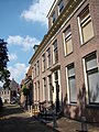
Category:Domineeswal 6, Blokzijl
| Object location | | View all coordinates using: OpenStreetMap |
|---|
building in Steenwijkerland, Netherlands  | |||||
| Upload media | |||||
| Instance of | |||||
|---|---|---|---|---|---|
| Location | Blokzijl, Overijssel, Netherlands | ||||
| Street address |
| ||||
| Located on street |
| ||||
| Heritage designation |
| ||||
 | |||||
|
This is a category about rijksmonument number 10454
|
| Address |
|
Media in category "Domineeswal 6, Blokzijl"
The following 4 files are in this category, out of 4 total.
-
 Blokzijl 108.JPG 2,448 × 3,264; 1.96 MB
-
 Domineeswal 6 Blokzijl.jpg 2,736 × 3,648; 1.05 MB
-
 Overzicht - Blokzijl - 20036444 - RCE.jpg 1,200 × 804; 266 KB
-
 Voorgevel - Blokzijl - 20036451 - RCE.jpg 807 × 1,200; 251 KB


