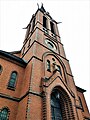
Category:Dorfchemnitzer Kirche
| Object location | | View all coordinates using: OpenStreetMap |
|---|
church building in Zwönitz, Germany  | |||||
| Upload media | |||||
| Instance of | |||||
|---|---|---|---|---|---|
| Location | Zwönitz, Erzgebirgskreis, Saxony, Germany | ||||
| Street address |
| ||||
| Heritage designation | |||||
| Inception |
| ||||
 | |||||
| (Wikidata) |
Media in category "Dorfchemnitzer Kirche"
The following 17 files are in this category, out of 17 total.
-
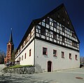 Fachwerkhaus und Kirche in Dorfchemnitz bei Zwonitz 2H1A8830WI.jpg 3,639 × 3,572; 2.77 MB
-
 Heimatkundelehrpfad Zwönitz, Die Dorfchemnitzer Kirche.jpg 3,000 × 4,000; 2.63 MB
-
 Kirche Dorfchemnitz (Zwönitz) (1).jpg 3,000 × 4,000; 3.77 MB
-
 Kirche Dorfchemnitz (Zwönitz) (2).jpg 3,000 × 4,000; 3.8 MB
-
 Kirche Dorfchemnitz (Zwönitz) mit Infotafel.jpg 3,024 × 4,032; 7.63 MB
-
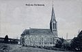 Kirche Dorfchemnitz 1907.jpg 573 × 368; 153 KB
-
 Kirche Dorfchemnitz.jpg 1,915 × 2,557; 757 KB
-
 Kirche in Dorfchemnitz bei Zwonitz 2H1A8840WI.jpg 2,436 × 3,150; 2.36 MB
-
 Kirche in Dorfchemnitz bei Zwonitz 2H1A8847WI.jpg 3,597 × 4,477; 6.7 MB
-
 Kirche in Dorfchemnitz bei Zwonitz. Erzgebirgskreis, Sachsen. 2H1A8864WI.jpg 3,094 × 3,750; 4.57 MB
-
 Kirche in Dorfchemnitz bei Zwoniz IMG 0798WI.jpg 3,648 × 5,472; 6.78 MB
-
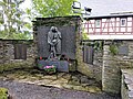
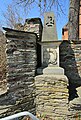 Sandsteinobelisk in Dorfchemnitz bei Zwonitz, Sachsen. 2H1A8853WI.jpg 3,648 × 5,390; 7.99 MB
-
 Zwönitz Dorfchemnitz church (1).jpg 3,337 × 4,451; 2.69 MB
-
 Zwönitz Dorfchemnitz church (2).jpg 3,456 × 4,608; 3.76 MB
-
 Zwönitz Dorfchemnitz church (3).jpg 3,456 × 4,608; 3.69 MB
-
 Zwönitz Dorfchemnitz church (4).jpg 4,608 × 3,456; 5.63 MB
-
 Zwönitz Dorfchemnitz church (5).jpg 3,456 × 4,608; 2.6 MB


_(1).jpg)
_(2).jpg)
_mit_Infotafel.jpg)


.jpg)
.jpg)
.jpg)
.jpg)
.jpg)