Category:Dorfkirche Göttin (Brandenburg)
| Object location | | View all coordinates using: OpenStreetMap |
|---|
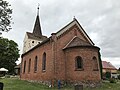
church building in Brandenburg state, Germany  | |||||
| Upload media | |||||
| Instance of | |||||
|---|---|---|---|---|---|
| Location | Göttin, Brandenburg, Brandenburg an der Havel, Brandenburg, Germany | ||||
| Heritage designation | |||||
 | |||||
This is the category of the Brandenburger Baudenkmal (cultural heritage monument) with the ID 09145237 (Wikidata)
|
Media in category "Dorfkirche Göttin (Brandenburg)"
The following 12 files are in this category, out of 12 total.
-
 Dorfkirche Göttin 2021 01.jpg 6,016 × 4,000; 14.32 MB
-
 Dorfkirche Göttin 2021 02.jpg 6,016 × 4,000; 16.73 MB
-
 Dorfkirche Göttin 2021 03.jpg 6,016 × 4,000; 13.87 MB
-
 Dorfkirche Göttin 2021 04.jpg 6,016 × 4,000; 18.75 MB
-
 Dorfkirche Göttin 2021 05.jpg 6,016 × 4,000; 11.71 MB
-
 Dorfkirche Göttin Ostansicht.jpg 3,024 × 4,032; 3.49 MB
-
 Dorfkirche Göttin Südansicht.jpg 4,032 × 3,024; 2.49 MB
-
 Dorfkirche Göttin Südostansicht.jpg 4,032 × 3,024; 3.18 MB
-
 Dorfkirche Göttin Westportal.jpg 3,024 × 4,032; 4.21 MB
-
 Dorfkirche Göttin Westturm Südwestansicht.jpg 3,024 × 4,032; 2.32 MB
-
 Dorfkirche Göttin Westturm Westansicht.jpg 3,024 × 4,032; 2.59 MB
-
 Kirche Göttin Brandenburg.jpg 4,928 × 3,264; 8.09 MB


