Category:Dorfkirche Rengerslage
| Object location | | View all coordinates using: OpenStreetMap |
|---|
church building in Osterburg (Altmark), Landkreis Stendal, Saxony-Anhalt, Germany  | |||||
| Upload media | |||||
| Instance of | |||||
|---|---|---|---|---|---|
| Location | Rengerslage, Königsmark, Stendal District, Saxony-Anhalt, Germany | ||||
| Heritage designation | |||||
 | |||||
This is the category of the Saxony-Anhalt Kulturdenkmal (cultural heritage monument) with the ID 09436426 (Wikidata)
|
English: Description in Georg Dehio Handbuch der deutschen Kunstdenkmäler, Sachsen-Anhalt I – Regierungsbezirk Magdeburg, Deutscher Kunstverlag 2002, ISBN 3-422-03069-7, p. 772
Media in category "Dorfkirche Rengerslage"
The following 4 files are in this category, out of 4 total.
-
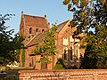
 Rengerslage029Kirche von NO.JPG 4,000 × 3,000; 5.01 MB
-
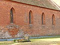 Rengerslage030Kirchenschiff von NO.JPG 4,000 × 3,000; 4.66 MB
-
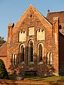 Rengerslage032Chorgiebel.JPG 3,000 × 4,000; 4.47 MB
-
 Rengerslage033Kirche von SO.JPG 4,000 × 3,000; 4.7 MB


