Category:Dorfkirche Stehla
| Camera location | | View all coordinates using: OpenStreetMap |
|---|
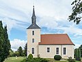
church building in Arzberg, Germany  | |||||
| Upload media | |||||
| Instance of | |||||
|---|---|---|---|---|---|
| Location | Arzberg, Nordsachsen, Saxony, Germany | ||||
| Street address |
| ||||
| Heritage designation | |||||
| Inception |
| ||||
 | |||||
| (Wikidata) |
Media in category "Dorfkirche Stehla"
The following 2 files are in this category, out of 2 total.
-
 Stehla Kirche.jpg 4,279 × 3,209; 3.63 MB
-
 StehlaKirche.JPG 2,864 × 2,144; 1.25 MB
