Category:Dorfkirche Wolterslage
| Object location | | View all coordinates using: OpenStreetMap |
|---|
 | |||||
| Upload media | |||||
| Instance of | |||||
|---|---|---|---|---|---|
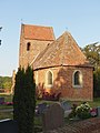
| Location | Wolterslage, Königsmark, Stendal District, Saxony-Anhalt, Germany | ||||
| Heritage designation | |||||
 | |||||
English: Description in Georg Dehio Handbuch der deutschen Kunstdenkmäler, Sachsen-Anhalt I – Regierungsbezirk Magdeburg, Deutscher Kunstverlag 2002, ISBN 3-422-03069-7, p. 1025
Media in category "Dorfkirche Wolterslage"
The following 4 files are in this category, out of 4 total.
-
 Wolterslage church.jpg 2,960 × 2,362; 805 KB
-
 Wolterslage034Kirche von O.jpg 3,000 × 4,000; 8.26 MB
-
 Wolterslage035KIrchturm von S.JPG 3,000 × 4,000; 4.48 MB
-
 Wolterslage036Kirche von S.jpg 4,000 × 3,000; 8.64 MB


