Category:Dorfmühle Mohorn
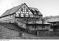
Deutsch: Dorfmühle Mohorn, Freiberger Straße 11; Mühlgraben mit dem Wasser der Triebisch.
| Object location | | View all coordinates using: OpenStreetMap |
|---|
 | |||||
| Upload media | |||||
 | |||||
Subcategories
This category has only the following subcategory.
- Interior of Dorfmühle Mohorn (22 F)
Media in category "Dorfmühle Mohorn"
The following 32 files are in this category, out of 32 total.
-
 Fotothek df rp-a 0640020 Wilsdruff-Mohorn. Dorfmühle, Ansicht.jpg 800 × 402; 139 KB
-
 Fotothek df rp-a 0640021 Wilsdruff-Mohorn. Dorfmühle, Ansicht.jpg 800 × 554; 191 KB
-
 Fotothek df rp-a 0710083 Wilsdruff-Mohorn. Dorfmühle, Ansicht.jpg 800 × 518; 194 KB
-

-
-
 Fotothek df rp-a 0890007 Wilsdruff-Mohorn. Dorfmühle, Ansicht.jpg 800 × 531; 208 KB
-
 Fotothek df rp-a 0890009 Wilsdruff-Mohorn. Dorfmühle, Ansicht.jpg 800 × 538; 219 KB
-
 Fotothek df rp-a 0980007 Wilsdruff-Mohorn. Dorfmühle, Ansicht.jpg 800 × 518; 119 KB
-
 Fotothek df rp-a 0980011 Wilsdruff-Mohorn. Dorfmühle, Ansicht.jpg 800 × 518; 195 KB
-
 Fotothek df rp-a 0980037 Wilsdruff-Mohorn. Dorfmühle, Ansicht.jpg 800 × 533; 213 KB
-

-

-

-

-
 Fotothek df rp-c 0130037 Wilsdruff-Mohorn. Dorfmühle, Ansicht.jpg 800 × 531; 187 KB
-
 Fotothek df rp-c 0130039 Wilsdruff-Mohorn. Dorfmühle, Ansicht.jpg 800 × 531; 183 KB
-
-
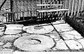
 Fotothek df rp-c 0290008 Wilsdruff-Mohorn. Dorfmühle, Trog.jpg 800 × 535; 178 KB
-
 Fotothek df rp-c 0290080 Wilsdruff-Mohorn. Grab von Max Schubert.jpg 800 × 518; 214 KB
-

-
 Fotothek df rp-c 0300004 Wilsdruff-Mohorn. Dorfmühle, Ansicht.jpg 800 × 536; 218 KB
-

-

-

-
 Fotothek df rp-c 0430020 Wilsdruff-Mohorn. Dorfmühle, Ansicht.jpg 800 × 544; 216 KB
-
 Fotothek df rp-c 0430022 Wilsdruff-Mohorn. Dorfmühle, Ansicht.jpg 800 × 531; 147 KB
-
 Fotothek df rp-c 0430024 Wilsdruff-Mohorn. Dorfmühle, Ansicht.jpg 800 × 531; 146 KB
-
 Fotothek df rp-c 0430026 Wilsdruff-Mohorn. Dorfmühle, Ansicht.jpg 800 × 255; 70 KB
-
 Fotothek df rp-c 0430030 Wilsdruff-Mohorn. Dorfmühle, Ansicht.jpg 800 × 522; 205 KB
-
 Fotothek df rp-c 0430032 Wilsdruff-Mohorn. Dorfmühle, Ansicht.jpg 800 × 544; 220 KB
-

-
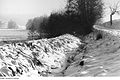
 Fotothek df rp-c 0490036 Wilsdruff-Mohorn. Dorfmühle, Mühlgraben.jpg 800 × 522; 178 KB


,_dahinter_das_Triebischtal.jpg)


