Category:Dorpskerk, Kethel
| Object location | | View all coordinates using: OpenStreetMap |
|---|
church building in Schiedam, Netherlands   | |||||
| Upload media | |||||
| Instance of | |||||
|---|---|---|---|---|---|
| Location | Kethel, Schiedam, South Holland, Netherlands | ||||
| Street address |
| ||||
| Located on street | |||||
| Heritage designation |
| ||||
 | |||||
|
This is a category about rijksmonument number 33299
|
| Address |
|
Media in category "Dorpskerk, Kethel"
The following 48 files are in this category, out of 48 total.
-
 Dorpskerk Kethel 2018 1 ShiftN.jpg 3,553 × 3,192; 2.25 MB
-
 Dorpskerk Kethel 2018 1.jpg 4,928 × 3,264; 7.63 MB
-
 Dorpskerk Kethel 2018 2.jpg 3,264 × 4,928; 6.65 MB
-
 Dorpskern uit het zuiden - Kethel - 20125004 - RCE.jpg 1,200 × 807; 157 KB
-
 Exterieur - Kethel - 20125013 - RCE.jpg 1,200 × 1,173; 380 KB
-
 Exterieur - Kethel - 20125019 - RCE.jpg 1,200 × 803; 206 KB
-
 Exterieur vanuit het noord-westen - Kethel - 20125018 - RCE.jpg 1,200 × 802; 187 KB
-
 Gezicht op het oude Dorp, vanuit het noord-oosten - Kethel - 20125003 - RCE.jpg 1,200 × 1,180; 296 KB
-
 Gezien naar het oosten, interieur - Kethel - 20125041 - RCE.jpg 967 × 1,200; 207 KB
-
 Grafmonument door J.Blommendaal, 1684 - Kethel - 20125015 - RCE.jpg 891 × 1,200; 188 KB
-
 Grafmonument door J.Blommendael, 1684 - Kethel - 20125049 - RCE.jpg 947 × 1,200; 204 KB
-
 Herenbank - Kethel - 20125046 - RCE.jpg 1,019 × 1,200; 204 KB
-
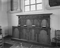 Herenbank - Kethel - 20125047 - RCE.jpg 1,200 × 954; 172 KB
-
 Interieur - Kethel - 20125014 - RCE.jpg 1,200 × 892; 179 KB
-
 Interieur naar het oosten - Kethel - 20125022 - RCE.jpg 1,200 × 953; 169 KB
-
 Interieur naar het oosten - Kethel - 20125042 - RCE.jpg 958 × 1,200; 207 KB
-
 Interieur naar het westen - Kethel - 20125020 - RCE.jpg 1,200 × 955; 210 KB
-
 Interieur naar het westen - Kethel - 20125043 - RCE.jpg 1,200 × 956; 194 KB
-
 Interieur naar het zuid-oosten - Kethel - 20125021 - RCE.jpg 1,200 × 949; 184 KB
-
 Interieur, aanzicht orgel, orgelnummer 779 - Schiedam - 20417422 - RCE.jpg 832 × 1,200; 142 KB
-
 Kansel met zuid-gevel - Kethel - 20125028 - RCE.jpg 1,200 × 1,177; 178 KB
-
 Kerk naar het noord-westen - Kethel - 20125017 - RCE.jpg 1,025 × 1,200; 313 KB
-
 Kerk oost-zijde - Kethel - 20125016 - RCE.jpg 966 × 1,200; 319 KB
-
 Kerk vanuit het noord-westen - Kethel - 20125011 - RCE.jpg 1,200 × 888; 283 KB
-
 Kerk vanuit het westen - Kethel - 20125010 - RCE.jpg 1,200 × 891; 297 KB
-
 Kerk vanuit het zuid-oosten - Kethel - 20125012 - RCE.jpg 1,200 × 885; 245 KB
-
 Naar het westen - Kethel - 20125027 - RCE.jpg 952 × 1,200; 253 KB
-
 Noord-gevel - Kethel - 20125024 - RCE.jpg 1,200 × 959; 242 KB
-
 Noordgevel - Kethel - 20125037 - RCE.jpg 1,200 × 959; 321 KB
-
 Oost gevel schip - Kethel - 20125025 - RCE.jpg 1,200 × 955; 155 KB
-
 Orgel - Kethel - 20125044 - RCE.jpg 957 × 1,200; 199 KB
-
 Overzicht - Kethel - 20125030 - RCE.jpg 1,200 × 955; 352 KB
-
 Overzicht - Kethel - 20125031 - RCE.jpg 1,200 × 949; 194 KB
-
 Overzicht - Kethel - 20125032 - RCE.jpg 1,200 × 942; 171 KB
-
 Overzicht - Kethel - 20125033 - RCE.jpg 1,200 × 951; 173 KB
-
 Overzicht vanuit het noord-oosten - Kethel - 20125034 - RCE.jpg 1,200 × 1,177; 249 KB
-
 Preekstoel - Kethel - 20125045 - RCE.jpg 957 × 1,200; 173 KB
-
 Schiedam-Kethel - Noordeinde 10.jpg 1,828 × 2,437; 1.4 MB
-
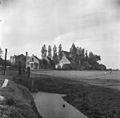
 Schiedam-Kethel met kerk.jpg 2,592 × 1,944; 1.43 MB
-
 Steunbeer west-zijde tegen de toren - Kethel - 20125023 - RCE.jpg 951 × 1,200; 358 KB
-
 Tiengebodenbord - Kethel - 20125048 - RCE.jpg 1,042 × 1,200; 183 KB
-
 Westgevel ingang toren - Kethel - 20125036 - RCE.jpg 964 × 1,200; 329 KB
-
 Westgevel toren - Kethel - 20125035 - RCE.jpg 953 × 1,200; 288 KB
-
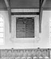
 Wetsborden - Kethel - 20125029 - RCE.jpg 1,200 × 1,175; 298 KB
-
 Zuid-gevel - Kethel - 20125026 - RCE.jpg 1,200 × 964; 239 KB
-
 Zuid-oostgevel - Kethel - 20125038 - RCE.jpg 1,200 × 959; 290 KB
-
 Zuidgevel - Kethel - 20125039 - RCE.jpg 1,200 × 958; 442 KB
-
 Zuidgevel ingang - Kethel - 20125040 - RCE.jpg 955 × 1,200; 350 KB


