Category:Dorpsstraat 25, Bakel
| Object location | | View all coordinates using: OpenStreetMap |
|---|
 | |||||
| Upload media | |||||
| Instance of | |||||
|---|---|---|---|---|---|
| Location | Bakel, North Brabant, Netherlands | ||||
| Street address |
| ||||
| Architectural style | |||||
| Heritage designation |
| ||||
 | |||||
|
This is a category about rijksmonument number 518091
|
| Address |
|
Media in category "Dorpsstraat 25, Bakel"
The following 3 files are in this category, out of 3 total.
-
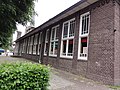 Bakel Rijksmonument 518091 voorm. lagere school.JPG 3,648 × 2,736; 4.15 MB
-
 Bakel Rijksmonument 518091 voorm. school, nu peuteropvang.JPG 2,736 × 3,648; 3.5 MB
-
 Bakel Rijksmonument 518091 voorm. school, veelhoekige schoorsteen.JPG 2,736 × 3,648; 2.75 MB

