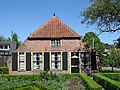
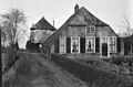
Category:Dorpsstraat 40, Renswoude
| Object location | | View all coordinates using: OpenStreetMap |
|---|
farmhouse in Renswoude, Netherlands  | |||||
| Upload media | |||||
| Instance of | |||||
|---|---|---|---|---|---|
| Location | Renswoude, Utrecht, Netherlands | ||||
| Street address |
| ||||
| Located on street |
| ||||
| Heritage designation |
| ||||
 | |||||
|
This is a category about rijksmonument number 32449
|
| Address |
|
Media in category "Dorpsstraat 40, Renswoude"
The following 9 files are in this category, out of 9 total.
-
 Renswoude - Dorpsstraat 40 - 1.JPG 2,592 × 1,944; 2.2 MB
-
 Renswoude - Dorpsstraat 40 - 2.JPG 2,592 × 1,944; 2.22 MB
-
 Renswoude - Dorpsstraat 40 - 3.JPG 2,592 × 1,944; 2.08 MB
-
 Renswoude Dorpsstraat 40 Achterzijde.jpg 4,376 × 3,432; 6.11 MB
-
 Renswoude Dorpsstraat 40 Hooiberg.jpg 3,353 × 4,535; 7.02 MB
-
 Renswoude Dorpsstraat 40 Schouw.jpg 3,120 × 4,534; 4.16 MB
-
 Renswoude Dorpsstraat 40 Zolder.jpg 4,608 × 3,456; 5.91 MB
-
 Voorgevel - Renswoude - 20185479 - RCE.jpg 1,200 × 809; 255 KB
-
 Voorgevel - Renswoude - 20185480 - RCE.jpg 1,200 × 794; 217 KB


