Category:Dowland
hamlet and civil parish in Devon, England  | |||||
| Upload media | |||||
| Instance of | |||||
|---|---|---|---|---|---|
| Location | Torridge, Devon, South West England, England | ||||
| Population |
| ||||
| Different from | |||||
 | |||||
Media in category "Dowland"
The following 47 files are in this category, out of 47 total.
-
 Arable field, Dowland - geograph.org.uk - 5797987.jpg 4,096 × 2,583; 2.35 MB
-
 B3217 approaching Dowland - geograph.org.uk - 3424794.jpg 517 × 640; 118 KB
-
 B3217 approaching Dowland - geograph.org.uk - 5784630.jpg 3,977 × 2,160; 1.44 MB
-
 B3217 south of Dowland - geograph.org.uk - 3424618.jpg 550 × 640; 90 KB
-
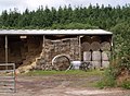 Barn at Mons Hall - geograph.org.uk - 483667.jpg 640 × 467; 115 KB
-
 Cattle at Dowland - geograph.org.uk - 5798058.jpg 4,288 × 2,848; 1.63 MB
-
 Cottage, Dowland (geograph 3424922).jpg 480 × 640; 102 KB
-

-
 Dowland Moor - geograph.org.uk - 480228.jpg 640 × 480; 108 KB
-
 Dowland, Pewson Barton - geograph.org.uk - 118976.jpg 640 × 419; 82 KB
-
 Dowland, Upcott - geograph.org.uk - 119004.jpg 640 × 427; 78 KB
-
 Field and boundary by Berry Wood - geograph.org.uk - 5797972.jpg 4,288 × 2,848; 2.67 MB
-
 Field boundary near Berry - geograph.org.uk - 3424582.jpg 640 × 457; 70 KB
-
 Fields at Upcott - geograph.org.uk - 3424546.jpg 640 × 401; 74 KB
-

-
 Former B3217 at Dowland - geograph.org.uk - 5784639.jpg 2,848 × 4,288; 2.54 MB
-
 Furzepark Cross - geograph.org.uk - 2811586.jpg 800 × 600; 381 KB
-
 Furzepark Cross - geograph.org.uk - 480283.jpg 640 × 469; 117 KB
-
 In the woods of Dowland Moor - geograph.org.uk - 2810050.jpg 800 × 600; 503 KB
-
 Junction, Monshall - geograph.org.uk - 5797728.jpg 4,288 × 2,848; 1.71 MB
-
 Lane near Pewson Barton - geograph.org.uk - 3424427.jpg 511 × 640; 96 KB
-
 Lane near Pewson Barton - geograph.org.uk - 3424438.jpg 640 × 480; 106 KB
-
 Lane to Furzepark Cross - geograph.org.uk - 3424403.jpg 499 × 640; 85 KB
-
 Loosedon Cross - geograph.org.uk - 2810013.jpg 800 × 600; 356 KB
-

-
 Mons Hall - geograph.org.uk - 480258.jpg 640 × 480; 117 KB
-
 Mons Hall and Berry - geograph.org.uk - 483630.jpg 640 × 480; 107 KB
-
 Oaks at Staple Farm - geograph.org.uk - 3425066.jpg 640 × 452; 68 KB
-

-

-
 Road to Dolton from Loosedon Cross - geograph.org.uk - 2810017.jpg 800 × 600; 341 KB
-
 Sheep near Lower Upcott - geograph.org.uk - 3424565.jpg 640 × 403; 55 KB
-
 Sheep near Lower Upcott - geograph.org.uk - 3424573.jpg 640 × 426; 64 KB
-
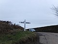
 Signpost at Dowland - geograph.org.uk - 3425055.jpg 640 × 480; 138 KB
-
 St Peter's Church, Dowland - geograph.org.uk - 3424927.jpg 480 × 640; 61 KB
-
 Staple Back Cross - geograph.org.uk - 2811553.jpg 800 × 600; 293 KB
-
 Staple Back Lane - geograph.org.uk - 2811559.jpg 800 × 600; 297 KB
-
 Staple Cross - geograph.org.uk - 2811571.jpg 800 × 600; 318 KB
-
 Staple Farm - geograph.org.uk - 3425080.jpg 640 × 465; 77 KB
-
 Stream near Monshall - geograph.org.uk - 5797967.jpg 2,848 × 4,288; 2.37 MB
-
 Tadpoles near Pewson Barton - geograph.org.uk - 3424451.jpg 640 × 480; 118 KB
-
 Tarka Trail northbound from Staple Cross - geograph.org.uk - 2811576.jpg 800 × 600; 356 KB
-

-

-
 Tilled field near Dowland - geograph.org.uk - 3424806.jpg 501 × 640; 121 KB
-
 West Upcott - geograph.org.uk - 3424486.jpg 640 × 436; 58 KB
-
 Winter trees at Loosedon Cross - geograph.org.uk - 2810024.jpg 800 × 600; 404 KB


.jpg)


