Category:Drevs gamla kyrka
| Object location | | View all coordinates using: OpenStreetMap |
|---|
|
This is a category about an ecclesiastical monument in Sweden, number 21300000004649 in the RAÄ buildings database.
|
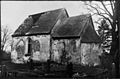
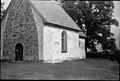
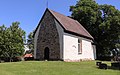
church building in Växjö Municipality, Sweden  | |||||
| Upload media | |||||
| Instance of | |||||
|---|---|---|---|---|---|
| Location | Växjö Municipality, Kronoberg County, Sweden | ||||
| Diocese | |||||
| Has use |
| ||||
| Occupant | |||||
| Heritage designation |
| ||||
| Inception |
| ||||
 | |||||
Subcategories
This category has only the following subcategory.
I
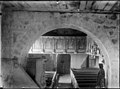
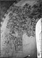
- Interior of Drevs gamla kyrka (29 F)
Media in category "Drevs gamla kyrka"
The following 120 files are in this category, out of 120 total.
-
 Drev old church 1920 from south east.jpg 826 × 545; 46 KB
-
 Drev old church 1920 with open roof.jpg 826 × 538; 45 KB
-
 Drevs gamla kyrka - KMB - 16000200069532.jpg 785 × 600; 57 KB
-
 Drevs gamla kyrka - KMB - 16000200069533.jpg 466 × 600; 36 KB
-
 Drevs gamla kyrka - KMB - 16000200069534.jpg 486 × 600; 30 KB
-
 Drevs gamla kyrka - KMB - 16000200069535.jpg 826 × 538; 37 KB
-
 Drevs gamla kyrka - KMB - 16000200069536.jpg 767 × 600; 15 KB
-
 Drevs gamla kyrka - KMB - 16000200069537.jpg 826 × 546; 59 KB
-
 Drevs gamla kyrka - KMB - 16000200069539.jpg 826 × 547; 48 KB
-
 Drevs gamla kyrka - KMB - 16000200069542.jpg 797 × 600; 47 KB
-
 Drevs gamla kyrka - KMB - 16000200069543.jpg 810 × 600; 45 KB
-
 Drevs gamla kyrka - KMB - 16000200069544.jpg 452 × 600; 30 KB
-
 Drevs gamla kyrka - KMB - 16000200069545.jpg 643 × 600; 32 KB
-
 Drevs gamla kyrka - KMB - 16000200069546.jpg 459 × 600; 31 KB
-
 Drevs gamla kyrka - KMB - 16000200069547.jpg 819 × 600; 69 KB
-
 Drevs gamla kyrka - KMB - 16000200069548.jpg 813 × 600; 83 KB
-
 Drevs gamla kyrka - KMB - 16000200069549.jpg 826 × 543; 48 KB
-
 Drevs gamla kyrka - KMB - 16000200069550.jpg 826 × 536; 27 KB
-
 Drevs gamla kyrka - KMB - 16000200069551.jpg 826 × 556; 45 KB
-
 Drevs gamla kyrka - KMB - 16000200069552.jpg 403 × 600; 25 KB
-
 Drevs gamla kyrka - KMB - 16000200069553.jpg 403 × 600; 29 KB
-
 Drevs gamla kyrka - KMB - 16000200069554.jpg 780 × 600; 30 KB
-
 Drevs gamla kyrka - KMB - 16000200069555.jpg 817 × 600; 30 KB
-
 Drevs gamla kyrka - KMB - 16000200069556.jpg 812 × 600; 29 KB
-
 Drevs gamla kyrka - KMB - 16000200069558.jpg 826 × 580; 46 KB
-
 Drevs gamla kyrka - KMB - 16000200069559.jpg 443 × 600; 19 KB
-
 Drevs gamla kyrka - KMB - 16000200069560.jpg 826 × 577; 72 KB
-
 Drevs gamla kyrka - KMB - 16000200069562.jpg 773 × 600; 38 KB
-
 Drevs gamla kyrka - KMB - 16000200069563.jpg 826 × 546; 48 KB
-
 Drevs gamla kyrka - KMB - 16000200069564.jpg 826 × 554; 38 KB
-
 Drevs gamla kyrka - KMB - 16000200069565.jpg 826 × 540; 40 KB
-
 Drevs gamla kyrka - KMB - 16000200069566.jpg 826 × 520; 62 KB
-
 Drevs gamla kyrka - KMB - 16000200069567.jpg 826 × 551; 42 KB
-
 Drevs gamla kyrka - KMB - 16000200069569.jpg 811 × 600; 37 KB
-
 Drevs gamla kyrka - KMB - 16000200069570.jpg 805 × 600; 39 KB
-
 Drevs gamla kyrka - KMB - 16000200069571.jpg 432 × 600; 23 KB
-
 Drevs gamla kyrka - KMB - 16000200069573.jpg 485 × 600; 24 KB
-
 Drevs gamla kyrka - KMB - 16000200069574.jpg 756 × 600; 36 KB
-
 Drevs gamla kyrka - KMB - 16000200069575.jpg 477 × 600; 24 KB
-
 Drevs gamla kyrka - KMB - 16000200069576.jpg 826 × 550; 34 KB
-
 Drevs gamla kyrka - KMB - 16000200069577.jpg 478 × 600; 17 KB
-
 Drevs gamla kyrka - KMB - 16000200069578.jpg 421 × 600; 15 KB
-
 Drevs gamla kyrka - KMB - 16000200069579.jpg 721 × 600; 39 KB
-
 Drevs gamla kyrka - KMB - 16000200069580.jpg 492 × 600; 28 KB
-
 Drevs gamla kyrka - KMB - 16000200069581.jpg 472 × 600; 19 KB
-
 Drevs gamla kyrka - KMB - 16000200069582.jpg 683 × 600; 96 KB
-
 Drevs gamla kyrka - KMB - 16000200069583.jpg 456 × 600; 20 KB
-
 Drevs gamla kyrka - KMB - 16000200069584.jpg 603 × 600; 22 KB
-
 Drevs gamla kyrka - KMB - 16000200069585.jpg 635 × 600; 26 KB
-
 Drevs gamla kyrka - KMB - 16000200069586.jpg 610 × 600; 22 KB
-
 Drevs gamla kyrka - KMB - 16000200069587.jpg 620 × 600; 27 KB
-
 Drevs gamla kyrka - KMB - 16000200069588.jpg 626 × 600; 30 KB
-
 Drevs gamla kyrka - KMB - 16000200069589.jpg 566 × 600; 15 KB
-
 Drevs gamla kyrka - KMB - 16000200069590.jpg 620 × 600; 27 KB
-
 Drevs gamla kyrka - KMB - 16000200069591.jpg 617 × 600; 24 KB
-
 Drevs gamla kyrka - KMB - 16000200069592.jpg 599 × 600; 24 KB
-
 Drevs gamla kyrka - KMB - 16000200069593.jpg 572 × 600; 36 KB
-
 Drevs gamla kyrka - KMB - 16000200069594.jpg 459 × 600; 30 KB
-
 Drevs gamla kyrka - KMB - 16000200069595.jpg 613 × 600; 26 KB
-
 Drevs gamla kyrka - KMB - 16000200069596.jpg 595 × 600; 23 KB
-
 Drevs gamla kyrka - KMB - 16000200069597.jpg 608 × 600; 27 KB
-
 Drevs gamla kyrka - KMB - 16000200069598.jpg 615 × 600; 25 KB
-
 Drevs gamla kyrka - KMB - 16000200069599.jpg 628 × 600; 35 KB
-
 Drevs gamla kyrka - KMB - 16000200069600.jpg 618 × 600; 83 KB
-
 Drevs gamla kyrka - KMB - 16000200069601.jpg 619 × 600; 24 KB
-
 Drevs gamla kyrka - KMB - 16000200069602.jpg 604 × 600; 32 KB
-
 Drevs gamla kyrka - KMB - 16000200069603.jpg 624 × 600; 30 KB
-
 Drevs gamla kyrka - KMB - 16000200069604.jpg 826 × 550; 29 KB
-
 Drevs gamla kyrka - KMB - 16000200069605.jpg 826 × 543; 31 KB
-
 Drevs gamla kyrka - KMB - 16000200069607.jpg 435 × 600; 29 KB
-
 Drevs gamla kyrka - KMB - 16000200069610.jpg 494 × 600; 18 KB
-
 Drevs gamla kyrka - KMB - 16000200069611.jpg 447 × 600; 18 KB
-
 Drevs gamla kyrka - KMB - 16000200069612.jpg 469 × 600; 15 KB
-
 Drevs gamla kyrka - KMB - 16000200069613.jpg 466 × 600; 14 KB
-
 Drevs gamla kyrka - KMB - 16000200069614.jpg 462 × 600; 24 KB
-
 Drevs gamla kyrka - KMB - 16000200069615.jpg 388 × 600; 13 KB
-
 Drevs gamla kyrka - KMB - 16000200069616.jpg 454 × 600; 31 KB
-
 Drevs gamla kyrka - KMB - 16000200069617.jpg 459 × 600; 29 KB
-
 Drevs gamla kyrka - KMB - 16000200069618.jpg 499 × 600; 29 KB
-
 Drevs gamla kyrka - KMB - 16000200069619.jpg 501 × 600; 27 KB
-
 Drevs gamla kyrka - KMB - 16000200069620.jpg 741 × 600; 32 KB
-
 Drevs gamla kyrka - KMB - 16000200069621.jpg 427 × 600; 18 KB
-
 Drevs gamla kyrka - KMB - 16000200069623.jpg 796 × 600; 70 KB
-
 Drevs gamla kyrka - KMB - 16000200069624.jpg 770 × 600; 49 KB
-
 Drevs gamla kyrka - KMB - 16000200069625.jpg 398 × 600; 17 KB
-
 Drevs gamla kyrka - KMB - 16000200069626.jpg 465 × 600; 23 KB
-
 Drevs gamla kyrka - KMB - 16000200069627.jpg 455 × 600; 22 KB
-
 Drevs gamla kyrka - KMB - 16000200069628.jpg 406 × 600; 22 KB
-
 Drevs gamla kyrka - KMB - 16000200069629.jpg 450 × 600; 21 KB
-
 Drevs gamla kyrka - KMB - 16000200069630.jpg 451 × 600; 25 KB
-
 Drevs gamla kyrka - KMB - 16000200069631.jpg 496 × 600; 13 KB
-
 Drevs gamla kyrka - KMB - 16000200069632.jpg 459 × 600; 14 KB
-
 Drevs gamla kyrka - KMB - 16000200069633.jpg 826 × 284; 23 KB
-
 Drevs gamla kyrka - KMB - 16000200069634.jpg 435 × 600; 33 KB
-
 Drevs gamla kyrka - KMB - 16000200069635.jpg 453 × 600; 47 KB
-
 Drevs gamla kyrka - KMB - 16000200069636.jpg 448 × 600; 49 KB
-
 Drevs gamla kyrka - KMB - 16000200069637.jpg 429 × 600; 31 KB
-
 Drevs gamla kyrka - KMB - 16000200069638.jpg 433 × 600; 26 KB
-
 Drevs gamla kyrka - KMB - 16000200069639.jpg 425 × 600; 25 KB
-
 Drevs gamla kyrka - KMB - 16000200069640.jpg 826 × 590; 72 KB
-
 Drevs gamla kyrka - KMB - 16000200069641.jpg 437 × 600; 13 KB
-
 Drevs gamla kyrka - KMB - 16000200069642.jpg 826 × 578; 23 KB
-
 Drevs gamla kyrka - KMB - 16000200069643.jpg 489 × 600; 33 KB
-
 Drevs gamla kyrka - KMB - 16000200069644.jpg 826 × 556; 50 KB
-
 Drevs gamla kyrka - KMB - 16000200069645.jpg 410 × 600; 28 KB
-
 Drevs gamla kyrka - KMB - 16000200069646.jpg 425 × 600; 15 KB
-
 Drevs gamla kyrka - KMB - 16000200071530.jpg 427 × 600; 26 KB
-
 Drevs gamla kyrka - KMB - 16000200071531.jpg 424 × 600; 13 KB
-
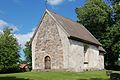
 Drevs gamla kyrka Exteriör 01.jpg 5,432 × 3,402; 14 MB
-
 Drevs gamla kyrka Exteriör 02.jpg 6,000 × 4,000; 3.06 MB
-
 Drevs gamla kyrka Exteriör 03.jpg 6,307 × 4,457; 3.2 MB
-
 Drevs gamla kyrka Exteriör 04.jpg 6,000 × 4,000; 2.57 MB
-
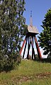 Drevs gamla kyrka Klockstapel 01.jpg 3,334 × 5,576; 16.96 MB
-
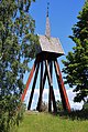 Drevs gamla kyrka Klockstapel 02.jpg 3,055 × 4,553; 3.12 MB
-
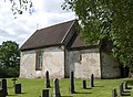
 Drevs gamla kyrka, sydsidan.JPG 3,872 × 2,592; 4.71 MB
-
 Drevs gamla kyrka.JPG 3,872 × 2,592; 4.63 MB
-
 Drevs gamla kyrka014.JPG 2,493 × 1,809; 2.4 MB
-
 Drevs gamla kyrka063.JPG 1,990 × 3,002; 2.19 MB
-
 Drevs gla kyrka 03.jpg 2,789 × 1,870; 917 KB
-
 Drevs gla kyrka04.JPG 2,537 × 1,858; 2.42 MB


