Category:Dub u Stonávky
| Object location | | View all coordinates using: OpenStreetMap |
|---|
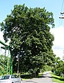
memorable tree in Karviná District, Czech Republic .JPG) | |||||
| Upload media | |||||
| Instance of |
| ||||
|---|---|---|---|---|---|
| Location | Stonava, Karviná District, Moravian-Silesian Region, Czechia | ||||
| Maintained by | |||||
| Height |
| ||||
 | |||||
Media in category "Dub u Stonávky"
The following 5 files are in this category, out of 5 total.
-
 Stonava, dub u Stonávky (1).JPG 2,834 × 3,664; 6.84 MB
-
 Stonava, dub u Stonávky (2).JPG 2,550 × 3,750; 7.22 MB
-
 Stonava, dub u Stonávky (3).JPG 2,959 × 3,809; 8.3 MB
-
 Stonava, dub u Stonávky (4).JPG 2,708 × 3,862; 7.12 MB
-
 Stonava, Dub u Stonávky.jpg 3,448 × 4,571; 5.45 MB
.JPG)
.JPG)
.JPG)
