Category:Dunedin Harbourside Historic Area
Historic Area in Dunedin, New Zealand  .jpg) | |||||
| Upload media | |||||
| Instance of |
| ||||
|---|---|---|---|---|---|
| Location | Dunedin, Dunedin City, Otago Region, New Zealand | ||||
| Street address |
| ||||
| Heritage designation |
| ||||
 | |||||
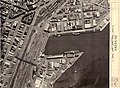
English: The Dunedin Harbourside Historic Area comprises 25, 31-33 Thomas Burns Street, Birch Street, Fryatt Street, Fish Street, Willis Street, Cresswell Street, Tewsley Street, Wharf Street, Roberts Street and Mason Street in Dunedin. The area is registered with the New Zealand Historic Places Trust as a Historic Area with the registration number 7767.
Subcategories
This category has the following 2 subcategories, out of 2 total.
Media in category "Dunedin Harbourside Historic Area"
This category contains only the following file.
-
 Dunedin wharves 1967 (37296179526).jpg 4,816 × 3,520; 5.76 MB