Category:Ebbesbourne Wake
village and civil parish in Wiltshire, United Kingdom  | |||||
| Upload media | |||||
| Instance of | |||||
|---|---|---|---|---|---|
| Location | Wiltshire, South West England, England | ||||
| Population |
| ||||
 | |||||
English: Ebbesbourne Wake is a civil parish in Wiltshire, England, about twelve miles (19 km) south-west of Salisbury, at . According to the 2001 census it had a population of 226.
Nederlands: Ebbesborne Wake is een dorp (village) en civil parish in de unitary authority Wiltshire, in het Engelse graafschap Wiltshire. De civil parish telt
Subcategories
This category has the following 4 subcategories, out of 4 total.
E
Media in category "Ebbesbourne Wake"
The following 177 files are in this category, out of 177 total.
-
 Agricultural machinery southwest of Chase Barn - geograph.org.uk - 4544686.jpg 1,920 × 1,286; 639 KB
-
 Balwen Sheep - geograph.org.uk - 682044.jpg 640 × 480; 139 KB
-
 Balwen Sheep near Ebbesbourne Wake - geograph.org.uk - 682034.jpg 640 × 480; 137 KB
-
 Belt of trees near East Combe Wood - geograph.org.uk - 4743991.jpg 1,920 × 1,260; 707 KB
-
 Bench Mark, No 1 Thatched Cottages - geograph.org.uk - 2800131.jpg 640 × 480; 79 KB
-
 Benchmark on May Bridge - geograph.org.uk - 2733610.jpg 800 × 651; 301 KB
-
 Bounds, Ebbesbourne Wake - geograph.org.uk - 2733525.jpg 640 × 480; 79 KB
-
 Bridge over dry stream bed, West End - geograph.org.uk - 6569640.jpg 1,024 × 683; 318 KB
-
 Bridleway, West End - geograph.org.uk - 1334166.jpg 640 × 481; 171 KB
-
 Buildings at Cleeves Farm - geograph.org.uk - 4743941.jpg 1,920 × 1,260; 660 KB
-
 Buildings at North Hill Farm - geograph.org.uk - 6569655.jpg 1,024 × 683; 285 KB
-
 Bunting's, Ebbesbourne Wake - geograph.org.uk - 2733001.jpg 640 × 481; 82 KB
-
 Bunting's, Ebbesbourne Wake - geograph.org.uk - 2733417.jpg 640 × 480; 83 KB
-
 Bus shelter, West End - geograph.org.uk - 2295594.jpg 480 × 640; 80 KB
-
 Buzzard (Buteo buteo) - geograph.org.uk - 2647607.jpg 640 × 480; 108 KB
-
 Buzzard (Buteo buteo) - geograph.org.uk - 2647609.jpg 640 × 481; 117 KB
-
 Byway approaching Chase Woods - geograph.org.uk - 4744108.jpg 1,920 × 1,439; 757 KB
-
 Byway by Barrow Hill - geograph.org.uk - 4743938.jpg 1,920 × 1,440; 648 KB
-
 Byway into Cranborne Chase - geograph.org.uk - 4744063.jpg 1,920 × 1,401; 786 KB
-
 Byway to Chase Woods - geograph.org.uk - 4744087.jpg 1,920 × 1,440; 964 KB
-
 Byway, North Hill Farm - geograph.org.uk - 1334184.jpg 640 × 480; 209 KB
-
 Byway, North Hill Farm - geograph.org.uk - 1334193.jpg 640 × 480; 249 KB
-
 Byway, Prescombe Down - geograph.org.uk - 1334226.jpg 640 × 480; 231 KB
-
 Byway, Prescombe Down - geograph.org.uk - 1334338.jpg 640 × 481; 185 KB
-
 Byway, West End - geograph.org.uk - 1334175.jpg 640 × 481; 218 KB
-
 Car park, Chalke Valley History Festival - geograph.org.uk - 4543503.jpg 1,920 × 1,232; 611 KB
-
 Car park, Chalke Valley History Festival - geograph.org.uk - 4743871.jpg 2,800 × 1,900; 871 KB
-
 Car park, Chalke Valley History Festival - geograph.org.uk - 4743899.jpg 1,920 × 1,335; 567 KB
-
 Church of St John the Baptist- benchmark - geograph.org.uk - 2733673.jpg 800 × 768; 283 KB
-
 Church of St John the Baptist- lych gate - geograph.org.uk - 2733714.jpg 800 × 647; 243 KB
-

-
 Church of St Martin - geograph.org.uk - 2803189.jpg 2,895 × 2,311; 1.97 MB
-
 Clapper over the Ebble - geograph.org.uk - 2792534.jpg 800 × 600; 297 KB
-
 Combe southwest of Chase Barn - geograph.org.uk - 4744075.jpg 1,920 × 1,235; 468 KB
-
 Combe southwest of Chase Barn - geograph.org.uk - 4744082.jpg 1,920 × 1,255; 772 KB
-
 Combe west of Chase Barn - geograph.org.uk - 4744071.jpg 1,920 × 1,340; 429 KB
-

-

-
 Demolition work, Fifield Bavant - geograph.org.uk - 2873100.jpg 640 × 481; 86 KB
-
 Demolition work, Manor Farm - geograph.org.uk - 2873243.jpg 640 × 480; 84 KB
-
 Detail, St Martin's Church - geograph.org.uk - 2008663.jpg 461 × 640; 159 KB
-

-
 Dry bed of River Ebble, Fifield Bavant - geograph.org.uk - 6569300.jpg 1,024 × 683; 208 KB
-
 Dry valley north of West End - geograph.org.uk - 6569646.jpg 1,024 × 683; 269 KB
-
 Duck Street, West End - geograph.org.uk - 6569653.jpg 1,024 × 683; 254 KB
-
 During a shower by East Combe Wood - geograph.org.uk - 4744020.jpg 1,920 × 1,440; 969 KB
-

-
 Ebbesbourne Wake, bus shelter - geograph.org.uk - 1030658.jpg 640 × 480; 118 KB
-
 Ebbesbourne Wake, down Duck Street - geograph.org.uk - 1030648.jpg 640 × 480; 111 KB
-
 Ebbesbourne Wake, Handley Street - geograph.org.uk - 1030653.jpg 480 × 640; 48 KB
-
 Ebbesbourne Wake, plaque at the old shop - geograph.org.uk - 1030463.jpg 640 × 480; 112 KB
-
 Ebbesbourne Wake, poignant gravestones - geograph.org.uk - 1031094.jpg 640 × 480; 123 KB
-
 Ebbesbourne Wake, Police postbox - geograph.org.uk - 1030662.jpg 427 × 555; 70 KB
-
 Ebbesbourne Wake, postbox No. SP5 23 - geograph.org.uk - 1030457.jpg 640 × 480; 109 KB
-
 Ebbesbourne Wake, postbox No. SP5 267 - geograph.org.uk - 1030465.jpg 640 × 480; 120 KB
-
 Ebbesbourne Wake, the chapel - geograph.org.uk - 1030467.jpg 640 × 480; 73 KB
-
 Ebbesbourne Wake, The Horseshoe - geograph.org.uk - 1030655.jpg 640 × 480; 83 KB
-

-
 Ebbesbourne Wake, the old school house - geograph.org.uk - 1030650.jpg 640 × 480; 111 KB
-
 Ebbesbourne Wake, Vine Cottages - geograph.org.uk - 1030665.jpg 640 × 480; 100 KB
-

-
 Edge of East Combe Wood - geograph.org.uk - 329336.jpg 640 × 430; 162 KB
-
 Entrance road to Chalke Valley History Festival - geograph.org.uk - 4543923.jpg 1,920 × 1,389; 725 KB
-
 Entrance road to Chalke Valley History Festival - geograph.org.uk - 4743905.jpg 1,920 × 1,440; 595 KB
-
 Exit from Chalke Valley History Festival - geograph.org.uk - 4743936.jpg 1,920 × 1,334; 763 KB
-
 Farm building - geograph.org.uk - 2803326.jpg 3,074 × 2,180; 1.61 MB
-
 Farm track at Fifield Ashes - geograph.org.uk - 5817212.jpg 1,024 × 683; 235 KB
-
 Farmland near Cleeves Farm - geograph.org.uk - 4743947.jpg 1,920 × 1,383; 804 KB
-

-
 Field by Ox Drove - geograph.org.uk - 4744024.jpg 2,816 × 2,112; 1.39 MB
-
 Field edge north of Fifield Bavant - geograph.org.uk - 5817210.jpg 1,024 × 683; 262 KB
-
 Field near Ebbesbourne Wake - geograph.org.uk - 4543894.jpg 1,920 × 1,336; 653 KB
-
 Fifield Bavant - St Martin's Church - geograph.org.uk - 5261341.jpg 1,920 × 2,560; 2.6 MB
-
 Fifield Bavant church - geograph.org.uk - 5299826.jpg 640 × 480; 121 KB
-
 Fifield Bavant Ford - geograph.org.uk - 4806879.jpg 1,086 × 724; 1.05 MB
-

-
 Fifield Fair, Fifield Bavant - geograph.org.uk - 2008612.jpg 640 × 480; 148 KB
-
 Fifield Fair, Fifield Bavant - geograph.org.uk - 2019091.jpg 640 × 480; 125 KB
-
 Fifield Fair, Fifield Bavant - geograph.org.uk - 2019098.jpg 640 × 491; 134 KB
-
 Fingerpost, Fifield Bavant - geograph.org.uk - 2873248.jpg 640 × 480; 81 KB
-
 Footbridge over a dry River Ebble - geograph.org.uk - 2792468.jpg 800 × 600; 282 KB
-
 Footpath, Ebbesbourne Wake - geograph.org.uk - 1820559.jpg 480 × 640; 232 KB
-
 Grass Covered Bridge - geograph.org.uk - 298960.jpg 480 × 640; 134 KB
-
 Grassy track on Ebbesborne Down - geograph.org.uk - 6569666.jpg 1,024 × 683; 218 KB
-
 Hillside, Cleeves Farm - geograph.org.uk - 4544117.jpg 1,920 × 1,334; 661 KB
-
 Information plaque on May Bridge - geograph.org.uk - 2733619.jpg 800 × 651; 281 KB
-

-
-

-

-

-

-
 Lambing pens, South Down - geograph.org.uk - 1221333.jpg 640 × 481; 108 KB
-
 Lane to Ebbesbourne Wake - geograph.org.uk - 1916127.jpg 640 × 480; 136 KB
-
 Leaning signpost of Ebbesbourne Wake - geograph.org.uk - 2733709.jpg 800 × 600; 299 KB
-

-
 Little grey fergie, Fifield Bavant - geograph.org.uk - 2019107.jpg 480 × 640; 176 KB
-
 Looking south across sunny fields - geograph.org.uk - 1916128.jpg 640 × 480; 148 KB
-
 May Bridge - geograph.org.uk - 2733596.jpg 800 × 595; 257 KB
-
 New House, Barrow Hill - geograph.org.uk - 2780283.jpg 640 × 480; 123 KB
-

-
 Old shed - geograph.org.uk - 2792548.jpg 3,264 × 2,448; 2.95 MB
-
 Ox Drove - geograph.org.uk - 4544652.jpg 1,920 × 1,440; 786 KB
-
 Ox Drove - geograph.org.uk - 4744055.jpg 1,920 × 1,440; 798 KB
-
 Ox Drove on South Down - geograph.org.uk - 4544674.jpg 1,920 × 1,440; 762 KB
-
 Ox Drove, South Down - geograph.org.uk - 1221328.jpg 640 × 481; 180 KB
-
 Path between crops towards Middle Down - geograph.org.uk - 6569670.jpg 1,024 × 683; 232 KB
-
 Plaque, Bunting's - geograph.org.uk - 2733415.jpg 640 × 312; 60 KB
-
 Ploughing, Fifield Bavant - geograph.org.uk - 2595797.jpg 640 × 480; 69 KB
-
 Prescombe Bottom - geograph.org.uk - 1334315.jpg 640 × 481; 150 KB
-
 Red-roofed house at West End - geograph.org.uk - 6569636.jpg 1,024 × 683; 248 KB
-
 River Ebble - geograph.org.uk - 5299824.jpg 640 × 480; 157 KB
-
 River Ebble at Stowford Bridge - geograph.org.uk - 6569304.jpg 1,024 × 683; 267 KB
-
 River Ebble, Fifield Bavant - geograph.org.uk - 2985871.jpg 1,600 × 1,067; 453 KB
-
 Rough grazing near Shermel Gate - geograph.org.uk - 1219994.jpg 640 × 480; 220 KB
-
 Scratch dial, St John the Baptist Church - geograph.org.uk - 2733501.jpg 640 × 480; 119 KB
-
 Sheep grazing above the river - geograph.org.uk - 310491.jpg 640 × 480; 59 KB
-
 Small wood, South Down - geograph.org.uk - 4744060.jpg 1,920 × 1,283; 527 KB
-

-

-

-

-

-

-

-

-

-

-

-

-

-

-

-

-

-

-

-

-

-

-

-

-

-

-

-

-

-

-

-

-
 St Martin's Church, Fifield Bavant - geograph.org.uk - 2800028.jpg 640 × 504; 80 KB
-
 St Martin's church, Fyfield Bavant - geograph.org.uk - 3076185.jpg 1,600 × 1,066; 340 KB
-
 St Martin's Church- kneelers - geograph.org.uk - 2803306.jpg 2,445 × 2,753; 1.32 MB
-
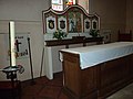
 St Martin's Church- the altar - geograph.org.uk - 2803291.jpg 2,926 × 2,291; 880 KB
-
 Stile and footpath, Prescombe Down - geograph.org.uk - 1334209.jpg 640 × 481; 231 KB
-
 Thatched cottages, Fifield Bavant - geograph.org.uk - 2800150.jpg 640 × 481; 80 KB
-
 Thatched cottages, Fifield Bavant - geograph.org.uk - 6569301.jpg 1,024 × 683; 258 KB
-
 The Horseshoe, Ebbesbourne Wake - geograph.org.uk - 1374406.jpg 640 × 480; 244 KB
-
 The rooftops of Ebbesbourne Wake - geograph.org.uk - 2733509.jpg 640 × 449; 89 KB
-
 Track and silo at North Hill Farm - geograph.org.uk - 6569658.jpg 1,024 × 683; 286 KB
-
 Track descending toward West End - geograph.org.uk - 6569648.jpg 1,024 × 683; 233 KB
-
 Track junction, Chase Woods - geograph.org.uk - 4544832.jpg 1,920 × 1,440; 1.07 MB
-
 Track over the hill to Hill Farm - geograph.org.uk - 310492.jpg 640 × 480; 73 KB
-
 Tractor at work, North Hill Farm - geograph.org.uk - 6569663.jpg 1,024 × 683; 215 KB
-
 Upstream from May Bridge - geograph.org.uk - 2733703.jpg 800 × 606; 260 KB
-
 View across field on Ebbesborne Down - geograph.org.uk - 6569660.jpg 1,024 × 683; 216 KB
-
 View from The Horseshoe's garden - geograph.org.uk - 1374413.jpg 640 × 480; 248 KB
-

-
 War memorial, Ebbesbourne Wake - geograph.org.uk - 3627008.jpg 640 × 480; 110 KB
-
 Weather vane, St Martin's Church - geograph.org.uk - 2800065.jpg 640 × 482; 42 KB
-
 West Wiltshire Downs landscape - geograph.org.uk - 3304400.jpg 3,264 × 2,448; 3.19 MB
-
 Wheat below Barrow Hill - geograph.org.uk - 4743922.jpg 2,816 × 2,112; 1.4 MB
-
 Woodland corner, Chase Woods - geograph.org.uk - 1221099.jpg 640 × 480; 186 KB
-
 Workshops, Manor Farm - geograph.org.uk - 2803332.jpg 2,939 × 2,180; 1.57 MB
-
 Chapel Cottage, Ebbesbourne Wake - geograph.org.uk - 323441.jpg 640 × 480; 106 KB
-
 Ebbesbourne Wake Chapel - geograph.org.uk - 323434.jpg 640 × 480; 93 KB
-
 Ebbesbourne Wake Village Hall - geograph.org.uk - 298956.jpg 640 × 480; 111 KB


_-_geograph.org.uk_-_2647607.jpg)
_-_geograph.org.uk_-_2647609.jpg)


_miles_-_geograph.org.uk_-_1030668.jpg)


_-_geograph.org.uk_-_3627011.jpg)
_-_geograph.org.uk_-_3627012.jpg)
_-_geograph.org.uk_-_3627159.jpg)
_-_geograph.org.uk_-_3627163.jpg)
_-_geograph.org.uk_-_3627165.jpg)
_-_geograph.org.uk_-_3627167.jpg)


_-_geograph.org.uk_-_3626985.jpg)
_-_geograph.org.uk_-_3626987.jpg)
_-_geograph.org.uk_-_3626991.jpg)
_-_geograph.org.uk_-_3626994.jpg)
_-_geograph.org.uk_-_3626998.jpg)
_-_geograph.org.uk_-_3627001.jpg)
_-_geograph.org.uk_-_3627003.jpg)


_-_geograph.org.uk_-_3627184.jpg)
_-_geograph.org.uk_-_3627191.jpg)
_-_geograph.org.uk_-_3627208.jpg)
_-_geograph.org.uk_-_3627210.jpg)
_-_geograph.org.uk_-_3627213.jpg)
_-_geograph.org.uk_-_3627215.jpg)
_-_geograph.org.uk_-_3627221.jpg)


_-_geograph.org.uk_-_3627396.jpg)
_-_geograph.org.uk_-_3627398.jpg)
_-_geograph.org.uk_-_3627401.jpg)


