Category:Edifício da Câmara Municipal do Funchal (Praça do Município, Funchal)
| Camera location | | View all coordinates using: OpenStreetMap |
|---|
Built about 1758 by D. Joana Teresa de Carvalho Esmeraldo and her husband, Sargento-mor Francisco Roque de Albuquerque Figueirôa, incorporating a number of 16th and 17th century buildings, as a residential town palace. Since 1868 Funchal's city hall has been installed here. In 1939-1940 a profound transformation took place, under project of architects Raul Lino and Carlos Ramos. The lateral and posterior facades date from that time.
building in Funchal .jpg)  | |||||
| Upload media | |||||
| Instance of | |||||
|---|---|---|---|---|---|
| Location | Sé, Funchal, Madeira, Portugal | ||||
| Located on street | |||||
| Architectural style | |||||
| Has use | |||||
| Heritage designation |
| ||||
| Inception |
| ||||
| Different from | |||||
 | |||||
Subcategories
This category has the following 2 subcategories, out of 2 total.
F
I
Media in category "Edifício da Câmara Municipal do Funchal (Praça do Município, Funchal)"
The following 16 files are in this category, out of 16 total.
-
 007 Funchal Cathedral.jpg 2,048 × 1,365; 703 KB
-

-
 Câmara Municipal do Funchal, Funchal - 2013-05-05 - DSC00406.jpg 3,240 × 4,320; 4.75 MB
-
 Câmara Municipal do Funchal, Madeira - 2020-01-03 - IMG 3698.jpg 4,608 × 3,456; 3.8 MB
-
 Câmara Municipal do Funchal, Madeira - 2020-01-03 - IMG 3699.jpg 4,608 × 3,456; 3.87 MB
-
 Funchal Town Hall - 2014-05-13.jpg 1,024 × 768; 146 KB
-
 Paços do Concelho, Funchal, Madeira - 2012-06-29 - DSC01991.jpg 3,240 × 4,320; 3.64 MB
-
 Paços do Concelho, Funchal, Madeira - 2012-06-29 - DSC01992.jpg 4,320 × 3,240; 3.87 MB
-
 Paços do Concelho, Funchal, Madeira - 2012-06-29 - DSC01993.jpg 4,320 × 3,240; 4.37 MB
-
 Paços do Concelho, Funchal, Madeira - 2012-06-29 - DSC01994.jpg 4,320 × 3,240; 4.82 MB
-
 Paços do Concelho, Funchal, Madeira - 2012-06-29 - DSC01995.jpg 3,240 × 4,320; 3.83 MB
-
 Paços do Concelho, Funchal, Madeira - 2012-06-29 - DSC01996.jpg 3,240 × 4,320; 3.9 MB
-
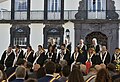 Tribuna de honra das cerimónias do Dia da Cidade - 2018-08-21 - Image 152004.jpg 1,280 × 876; 178 KB
-
 Tribuna para Dia da Cidade - 2018-08-21 - Image 151838.jpg 1,280 × 1,207; 228 KB
-
 Vereadores nas cerimónias do Dia da Cidade - 2018-08-21 - Image 151992.jpg 1,280 × 899; 198 KB
-
 Virgílio Gomes nas cerimónias do Dia da Cidade - 2018-08-21 - Image 154155.jpg 1,316 × 640; 237 KB


