Category:Edinburgh Trams maps (proposed lines)
Maps relating to the various proposed routes of the Edinburgh Trams system. For maps of the line as built, see Category:Edinburgh Trams maps (as built).
Media in category "Edinburgh Trams maps (proposed lines)"
The following 10 files are in this category, out of 10 total.
-
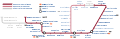
 Edinburgh Gateway tram connections.jpg 1,531 × 655; 568 KB
-
 Edinburgh trams and suburban railway 2023.svg 838 × 449; 117 KB
-
 Edinburgh trams and suburban railway.svg 838 × 449; 110 KB
-
 Edinburgh trams initial service.png 1,800 × 700; 143 KB
-
 Edinburgh Trams line 1.png 1,800 × 584; 137 KB
-
 Edinburgh Trams line 2.png 1,800 × 584; 134 KB
-
 Edinburgh Trams line 3.png 1,800 × 1,269; 185 KB
-
 Edinburgh tramway map.svg 850 × 275; 202 KB
-
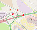 Map of proposed Edinburgh Gateway station (annotated).jpg 1,050 × 866; 371 KB
-
 Map of proposed Edinburgh Gateway station.jpg 1,050 × 866; 114 KB


.jpg)
