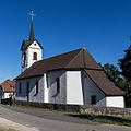
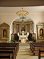
Category:Eglise St-Pierre-et-St-Paul (Haut du Village 20, Les Pommerats)
| Object location | | View all coordinates using: OpenStreetMap |
|---|
church building in Les Pommerats in the canton of Jura, Switzerland   | |||||
| Upload media | |||||
| Instance of | |||||
|---|---|---|---|---|---|
| Part of | |||||
| Location | Les Pommerats, Saignelégier, Franches-Montagnes District, Jura, Switzerland | ||||
| Street address |
| ||||
| Heritage designation | |||||
 | |||||
Media in category "Eglise St-Pierre-et-St-Paul (Haut du Village 20, Les Pommerats)"
The following 4 files are in this category, out of 4 total.
-
 2016-Les-Pommerats-Eglise.jpg 1,280 × 1,280; 1.65 MB
-
 Pommerats1.jpg 375 × 500; 55 KB
-
 Pommerats2.jpg 450 × 600; 48 KB
-
 Pommerats3.jpg 361 × 482; 35 KB

