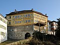
Category:Ehregutaplatz 1 (Bregenz)
| Object location | | View all coordinates using: OpenStreetMap |
|---|
building in Bregenz, Austria  | |||||
| Upload media | |||||
| Instance of | |||||
|---|---|---|---|---|---|
| Location | Bregenz, Bregenz District, Vorarlberg, Austria | ||||
| Street address |
| ||||
| Heritage designation | |||||
 | |||||
Media in category "Ehregutaplatz 1 (Bregenz)"
The following 23 files are in this category, out of 23 total.
-
 Bregenz - Stadtsteig (27159054820).jpg 2,048 × 1,360; 1.4 MB
-
 Bregenz, das Untere Tor der Oberstadt.jpg 1,638 × 2,398; 1.02 MB
-
 Bregenz, die Häuser Martinsgasse 1 und Ehregutaplatz 1.jpg 2,551 × 1,701; 1.28 MB
-

-
 EhregutaPlatz 01.jpg 2,452 × 3,269; 3.96 MB
-
 EhregutaPlatz 02.jpg 2,592 × 3,036; 3.59 MB
-
 Ehregutaplatz 1 Bregenz .JPG 4,800 × 3,200; 10.02 MB
-
 Ehregutaplatz 1 Bregenz.JPG 3,200 × 4,800; 9.69 MB
-
 Ehregutaplatz 1+1a, Bregenz.jpg 3,806 × 3,239; 8.85 MB
-
 Ehregutaplatz 1, Bregenz 1.JPG 2,550 × 3,400; 6.36 MB
-
 Ehregutaplatz 1, Bregenz 2.JPG 3,732 × 2,799; 8.09 MB
-
 Ehregutaplatz 1, Bregenz 3.JPG 3,484 × 2,613; 6.72 MB
-
 Ehregutaplatz 1, Bregenz 4.JPG 2,846 × 3,794; 5.58 MB
-
 Ehregutaplatz 1, Bregenz.jpg 3,909 × 2,606; 6.33 MB
-
 Eingang Ehreguta Platz 1.JPG 2,848 × 4,288; 6.22 MB
-
 Puerta Baja, Bregenz, Austria, 2022-10-22, DD 114-116 HDR.jpg 4,291 × 6,436; 10.91 MB
-
 Spruch am Eingang zur Oberstadt von Bregenz.JPG 4,000 × 3,000; 2.35 MB
-
 Stadttor - Unteres Tor.jpg 2,014 × 3,039; 4.78 MB
-
 Stadttor - Unteres Tor1.jpg 3,039 × 2,014; 4.69 MB
-
 Stadttor - Unteres Tor2.jpg 3,008 × 2,000; 4.34 MB
-
 Stadttor - Unteres Tor3.jpg 2,000 × 3,008; 4.09 MB
-
 Stadttor - Unteres Tor4.jpg 2,000 × 3,008; 4.24 MB
-
 UntereTorOberstadt.jpg 2,592 × 3,888; 3.43 MB
.jpg)


.JPG)


