Category:Election maps of Manipur
States of India: Andhra Pradesh · Arunachal Pradesh · Assam · Bihar · Chhattisgarh · Goa · Gujarat · Haryana · Himachal Pradesh · Jharkhand · Karnataka · Kerala · Madhya Pradesh · Maharashtra · Manipur · Meghalaya · Mizoram · Nagaland · Odisha · Punjab · Rajasthan · Sikkim · Tamil Nadu · Telangana · Tripura · Uttar Pradesh · Uttarakhand · West Bengal
Union territories: Andaman and Nicobar Islands · Chandigarh · Dadra and Nagar Haveli and Daman and Diu · Delhi · Jammu and Kashmir · Puducherry
Former states of India: Jammu and Kashmir ·
Former union territories:
Union territories: Andaman and Nicobar Islands · Chandigarh · Dadra and Nagar Haveli and Daman and Diu · Delhi · Jammu and Kashmir · Puducherry
Former states of India: Jammu and Kashmir ·
Former union territories:
Media in category "Election maps of Manipur"
The following 15 files are in this category, out of 15 total.
-
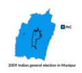 2009 Indian general election in Manipur.png 585 × 524; 38 KB
-
 2014 Indian general election in Manipur.png 585 × 524; 32 KB
-
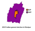 2019 Indian general election in Manipur.png 585 × 524; 33 KB
-
 2019 Lok Sabha in Manipur.svg 706 × 750; 1.59 MB
-
 2024 Lok Sabha NDA Alliance Seat Sharing Manipur.svg 650 × 650; 878 KB
-
 Kartik Chauhandehra manipur map.svg 800 × 800; 2.5 MB
-
 Kartik SVG Manipur 2022 Elections 2.svg 800 × 800; 1.27 MB
-
 Kartik SVG Manipur 2022 Elections 21.svg 800 × 800; 1.27 MB
-
 Kartik SVG Manipur 2022 Elections.svg 512 × 512; 399 KB
-
 Manipur 2012 Election SVG Kartik Chauhandehra.svg 800 × 800; 1.27 MB
-
 Manipur 2024 Results (Lok Sabha).png 720 × 857; 280 KB
-
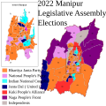
 Manipur Election 2022 Phases.png 834 × 954; 764 KB
-
 Manipur election, 2017 (Tamil).png 1,088 × 1,719; 189 KB
-
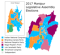 Manipur election, 2017.png 861 × 786; 172 KB
-
 Manipur Lok Sabha election result 2019.png 720 × 708; 55 KB


.png)

.png)

