Category:Elsässli
| Object location | | View all coordinates using: OpenStreetMap |
|---|
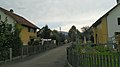
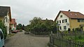
Deutsch: Das "Elsässli" ist eine historische Arbeitersiedlung in Derendingen, Kanton Solothurn, Schweiz. Sie ist ein Kulturgut von regionaler Bedeutung (KGS-Nr.: 4524).
English: "Elsässli" is a historical worker's housing estate in Derendingen, canton of Solothurn, Switzerland. It is listed as a cultural heritage monument of regional significance (KGS no.: 4524).
residential buildings in Derendingen in the canton of Solothurn, Switzerland  | |||||
| Upload media | |||||
| Instance of | |||||
|---|---|---|---|---|---|
| Part of | |||||
| Location | Derendingen, Wasseramt District, Bucheggberg-Wasseramt, Solothurn, Switzerland | ||||
| Street address |
| ||||
| Heritage designation | |||||
 | |||||
Media in category "Elsässli"
The following 3 files are in this category, out of 3 total.
-
 Derendingen Elsaessli 01.jpg 3,840 × 2,160; 6.22 MB
-
 Derendingen Elsaessli 02.jpg 3,840 × 2,160; 5.43 MB
-
 Derendingen Elsaessli 03.jpg 3,840 × 2,160; 5.51 MB

