Category:England Exactly Described (Thomas Taylor, 1715)
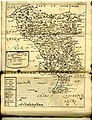
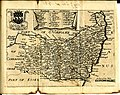
English: 38 old maps of England folded and bound in a leather book. This appears to be England Exactly Described published by Thomas Taylor in 1715.
"Taylor was also responsible for the publication of several maps including England exactly described [...] in 1715 containing maps of the English counties which had been issued previously in Speed's Maps Epitomiz'd in 1681 and in other works." (http://www.llgc.org.uk/index.php?id=thomastayloratlas5210)
Most seem to have been printed from copper plates made by Richard Blome in the 1660s and 1670s. The plates were modified and Bloom's name was removed from many of the plates before this set of maps was printed at a later date. Most of the plates measured 9 x 7-1/2 inches. The book was found in New Jersey, USA.
Subcategories
This category has only the following subcategory.
Media in category "England Exactly Described (Thomas Taylor, 1715)"
The following 40 files are in this category, out of 40 total.
-
 Maps of England circa 1670, leather cover, 1 of 40 (13431578834).jpg 2,957 × 5,564; 1.44 MB
-
 Maps of England circa 1670, title page 2 of 40 (13431342353).jpg 6,449 × 3,574; 2.28 MB
-
 Maps of England circa 1670, Barkshire 3 of 40 (13433994184).jpg 6,426 × 4,995; 3.9 MB
-
 Maps of England circa 1670, Bedford Shire 4 of 40 (13433968314).jpg 4,995 × 6,298; 3.58 MB
-
 Maps of England circa 1670, Buckingham Shire 5 of 40 (13433703943).jpg 4,995 × 6,426; 4.07 MB
-
 Maps of England circa 1670, CambridgeShire 6 of 40 (13433548945).jpg 4,995 × 6,426; 3.97 MB
-
 Maps of England circa 1670, Chester 7 of 40 (13433710295).jpg 6,333 × 4,995; 4.17 MB
-
 Maps of England circa 1670, Cornwal 8 of 40 (13433812923).jpg 6,565 × 4,925; 4.19 MB
-
 Maps of England circa 1670, Cumberland, Westmoreland 9 of 40 (13433786323).jpg 4,925 × 6,565; 4.66 MB
-
 Maps of England circa 1670, Darbie 10 of 40 (13433308993).jpg 4,925 × 6,402; 3.99 MB
-
 Maps of England circa 1670, Devon Shire 11 of 40 (13433371425).jpg 6,402 × 4,971; 4.04 MB
-
 Maps of England circa 1670, Dorset 12 of 40 (13433715094).jpg 6,402 × 4,971; 4.34 MB
-
 Maps of England circa 1670, Durham 13 of 40 (13433688254).jpg 6,449 × 4,971; 3.82 MB
-
 Maps of England circa 1670, Essex 14 of 40 (13433665924).jpg 6,449 × 4,971; 3.91 MB
-
 Maps of England circa 1670, Glocester 15 of 40 (13433425095).jpg 4,971 × 6,449; 4.49 MB
-
 Maps of England circa 1670, Hantshire 16 of 40 (13433390413).jpg 6,449 × 4,971; 4.03 MB
-
 Maps of England circa 1670, Hartford Shire 18 of 40 (13433335073).jpg 4,912 × 3,469; 2.54 MB
-
 Maps of England circa 1670, Hereford 17 of 40 (13433241815).jpg 6,507 × 4,936; 4.09 MB
-
 Maps of England circa 1670, Huntington 19 of 40 (13433397425).jpg 4,983 × 6,333; 4.03 MB
-
 Maps of England circa 1670, Kent 20 of 40 (13433110903).jpg 6,333 × 4,983; 4.21 MB
-
 Maps of England circa 1670, Lancashire 21 of 40 (13432454715).jpg 4,983 × 6,333; 4.18 MB
-
 Maps of England circa 1670, Leicester 22 of 40 (13432928824).jpg 6,333 × 4,983; 4.06 MB
-
 Maps of England circa 1670, Lyncolne 23 of 40 (13433391974).jpg 4,983 × 6,333; 4.3 MB
-
 Maps of England circa 1670, Midlesex 24 of 40 (13432580105).jpg 6,333 × 4,983; 3.89 MB
-
 Maps of England circa 1670, Monmouth 25 of 40 (13432398845).jpg 4,983 × 6,333; 3.93 MB
-
 Maps of England circa 1670, Norfolke 26 of 40 (13432983484).jpg 6,600 × 4,983; 4.65 MB
-
 Maps of England circa 1670, Northampton 27 of 40 (13432747854).jpg 6,542 × 4,948; 4.24 MB
-
 Maps of England circa 1670, Northumberland 28 of 40 (13432506245).jpg 4,948 × 6,274; 4.03 MB
-
 Maps of England circa 1670, Nottingham 29 of 40 (13433083003).jpg 4,948 × 6,274; 3.71 MB
-
 Maps of England circa 1670, Rutland 30 of 40 (13431915545).jpg 6,368 × 4,971; 3.66 MB
-
 Maps of England circa 1670, Shropshire 31 of 40 (13431535633).jpg 6,228 × 4,971; 4.31 MB
-
 Maps of England circa 1670, Somerset 32 of 40 (13431757184).jpg 6,298 × 4,971; 4.34 MB
-
 Maps of England circa 1670, Stafford Shire 33 of 40 (13432256853).jpg 6,298 × 4,971; 4.22 MB
-
 Maps of England circa 1670, Suffolk 34 of 40 (13431701714).jpg 6,298 × 4,971; 3.92 MB
-
 Maps of England circa 1670, Surrey 35 of 40 (13431423483).jpg 4,978 × 3,534; 2.68 MB
-
 Maps of England circa 1670, Sussex 36 of 40 (13432234744).jpg 5,038 × 3,435; 2.6 MB
-
 Maps of England circa 1670, Warwick 7 of 40 (13431666543).jpg 4,809 × 4,568; 3.01 MB
-
 Maps of England circa 1670, Wiltshire 38 of 40 (13432166465).jpg 6,298 × 4,971; 4.21 MB
-
 Maps of England circa 1670, Worcester 39 of 40 (13431941215).jpg 6,298 × 4,971; 4.09 MB
-
 Maps of England circa 1670, Yorkshire 40 of 40 (13431839974).jpg 6,414 × 4,971; 4.65 MB
.jpg)
.jpg)
.jpg)
.jpg)
.jpg)
.jpg)
.jpg)
.jpg)
.jpg)
.jpg)
.jpg)
.jpg)
.jpg)
.jpg)
.jpg)
.jpg)
.jpg)
.jpg)
.jpg)
.jpg)
.jpg)
.jpg)
.jpg)
.jpg)
.jpg)
.jpg)
.jpg)
.jpg)
.jpg)
.jpg)
.jpg)
.jpg)
.jpg)
.jpg)
.jpg)
.jpg)
.jpg)
.jpg)
.jpg)
.jpg)