Category:Erlöserkirche (Chemnitz)
| Object location | | View all coordinates using: OpenStreetMap |
|---|
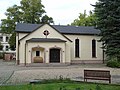
Deutsch: Evangelisch-methodistische Kirche, Gemeindebezirk Mittelsachsen, Erlöserkirche Chemnitz; Dresdner Straße 111a, Zugang über Klarastraße
 | |||||
| Upload media | |||||
| Instance of | |||||
|---|---|---|---|---|---|
| Location | Hilbersdorf, Chemnitz, Saxony, Germany | ||||
| Located on street |
| ||||
 | |||||
Media in category "Erlöserkirche (Chemnitz)"
This category contains only the following file.
-
 Erlöserkirche Chemnitz.JPG 2,592 × 1,944; 4.39 MB