Category:Esweg 12 (Norg)
| Object location | | View all coordinates using: OpenStreetMap |
|---|
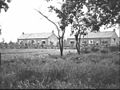
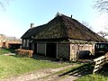
farmhouse in Noordenveld, Netherlands  | |||||
| Upload media | |||||
| Instance of | |||||
|---|---|---|---|---|---|
| Location | Norg, Drenthe, Netherlands | ||||
| Street address |
| ||||
| Located on street |
| ||||
| Heritage designation |
| ||||
 | |||||
|
This is a category about rijksmonument number 30788
|
| Address |
|
Media in category "Esweg 12 (Norg)"
The following 19 files are in this category, out of 19 total.
-
 Boerderij - Norg - 20467134 - RCE.jpg 1,200 × 900; 205 KB
-
 Boerderij - Norg - 20467135 - RCE.jpg 1,200 × 900; 140 KB
-
 Boerderij - Norg - 20467139 - RCE.jpg 1,200 × 900; 161 KB
-
 Boerderij - Norg - 20467140 - RCE.jpg 1,200 × 900; 148 KB
-
 Boerderij - Norg - 20467141 - RCE.jpg 1,200 × 900; 187 KB
-
 Boerderij - Norg - 20467142 - RCE.jpg 1,200 × 900; 116 KB
-
 Boerderij - Norg - 20467143 - RCE.jpg 1,200 × 900; 130 KB
-
 Boerderij - Norg - 20467144 - RCE.jpg 1,200 × 900; 154 KB
-
 Boerderij - Norg - 20467145 - RCE.jpg 1,200 × 900; 200 KB
-
 Boerderij - Norg - 20467146 - RCE.jpg 1,200 × 900; 201 KB
-
 Boerderij - Norg - 20467147 - RCE.jpg 1,200 × 900; 130 KB
-
 Boerderij - Norg - 20467148 - RCE.jpg 1,200 × 900; 198 KB
-
 Boerderij 1846 SVEN NORG 12 - Norg - 20467138 - RCE.jpg 1,200 × 900; 193 KB
-
 Boerderij Esweg 12 v1.jpg 4,608 × 3,456; 3.02 MB
-
 Boerderij Esweg 12 v2.jpg 4,608 × 3,456; 3.25 MB
-
 Boerderij nr. F 143-10 - Norg - 20467136 - RCE.jpg 1,200 × 900; 155 KB
-
 Boerderij nr. F 143-11 - Norg - 20467137 - RCE.jpg 1,200 × 900; 131 KB
-
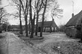
 Exterieur - Norg - 20170061 - RCE.jpg 1,200 × 952; 295 KB
-
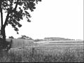
 Zuid-oost deel van het dorp vanuit het zuid-westen - Norg - 20169932 - RCE.jpg 1,200 × 797; 241 KB


