Category:Exaltation of the Holy Cross church in Zaleska Wola
| Object location | | View all coordinates using: OpenStreetMap |
|---|
church building in Zaleska Wola, Podkarpackie Voivodeship, Poland  | |||||
| Upload media | |||||
| Instance of | |||||
|---|---|---|---|---|---|
| Named after | |||||
| Made from material | |||||
| Location | Zaleska Wola, Podkarpackie Voivodeship, Gmina Radymno, Jarosław County, Subcarpathian Voivodeship, Poland | ||||
 | |||||
Media in category "Exaltation of the Holy Cross church in Zaleska Wola"
The following 4 files are in this category, out of 4 total.
-
 Zaleska Wola, kościół Podwyższenia Krzyża Świętego, widok od południa.jpg 3,762 × 2,402; 6.44 MB
-
 Zaleska Wola, kościół Podwyższenia Krzyża Świętego, widok od wschodu.jpg 3,872 × 2,592; 2.42 MB
-
 Zaleska Wola, kościół Podwyższenia Krzyża Świętego, widok od zachodu.jpg 1,447 × 1,699; 1.47 MB
-
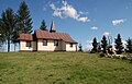
 Zaleska Wola, Kościół Podwyższenia Krzyża Świętego, widok ogólny.jpg 3,180 × 2,120; 4.08 MB


