Category:Fairfield Horseshoe
Hill-walking circular route from Ambleside.  | |||||
| Upload media | |||||
| Instance of |
| ||||
|---|---|---|---|---|---|
| Location | England | ||||
| Length |
| ||||
| |||||
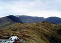
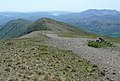
Fairfield Horseshoe, a walking route from Ambleside, Cumbria.
Nab Scar, Heron Pike, Great Rigg, Fairfield, Hart Crag, Dove Crag, High Pike and Low Pike in a circuit of Rydale.
Subcategories
This category has the following 7 subcategories, out of 7 total.
F
- Fairfield, Cumbria (44 F)
G
- Great Rigg (19 F)
H
- Hart Crag (19 F)
- Heron Pike (26 F)
- High Pike (Scandale) (14 F)
L
- Low Pike (Scandale) (16 F)
N
- Nab Scar (20 F)
Media in category "Fairfield Horseshoe"
The following 15 files are in this category, out of 15 total.
-

-
 Descending the Fairfield Horseshoe - geograph.org.uk - 1047385.jpg 640 × 464; 43 KB
-
 Erne Crag on the Fairfield Horseshoe - geograph.org.uk - 4711816.jpg 4,608 × 3,456; 4.35 MB
-
 Fairfield above Rydal Head - geograph.org.uk - 5327260.jpg 1,024 × 769; 130 KB
-
 Fairfield from Windermere.jpg 5,184 × 3,456; 1.6 MB
-
 Fairfield Horseshoe - geograph.org.uk - 1615170.jpg 640 × 433; 65 KB
-
 Fairfield Horseshoe from Sweden Bridge Lane - geograph.org.uk - 2571049.jpg 3,968 × 2,976; 2.95 MB
-
 Fairfield Horseshoe from Wansfell - geograph.org.uk - 1332935.jpg 640 × 480; 115 KB
-
 Fairfield Horseshoe.jpg 1,628 × 1,161; 100 KB
-
 Fairfield, the Great Rigg path - geograph.org.uk - 2391629.jpg 640 × 434; 189 KB
-

-
 South from Fairfield - geograph.org.uk - 2631417.jpg 640 × 425; 227 KB
-
 The Fairfield Horseshoe - geograph.org.uk - 6218406.jpg 640 × 360; 101 KB
-
 Walkers on the Fairfield Horseshoe - geograph.org.uk - 4711896.jpg 4,608 × 3,456; 3.53 MB
-
 Waterhead and the Fairfield Horseshoe from Holme Crag - geograph.org.uk - 3756083.jpg 5,184 × 3,456; 3.31 MB


