Category:Farmhouse, Dorf 247, Lauenen
| Object location | | View all coordinates using: OpenStreetMap |
|---|
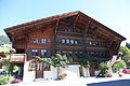
residential building in Lauenen in the canton of Bern, Switzerland  | |||||
| Upload media | |||||
| Instance of | |||||
|---|---|---|---|---|---|
| Part of | |||||
| Location | Lauenen, Obersimmental-Saanen administrative district, Oberland administrative region, Bern, Switzerland | ||||
| Street address |
| ||||
| Heritage designation | |||||
| Inception |
| ||||
 | |||||
Media in category "Farmhouse, Dorf 247, Lauenen"
The following 2 files are in this category, out of 2 total.
-
 Alte Mühle Lauenen.JPG 5,616 × 3,744; 7.45 MB
-
 PBK, uitg. Foto Villiger Gstaad, Zwi - Unknown - 20463211 - RCE.jpg 1,200 × 900; 265 KB
