Category:Fearnley, Birkenhead
| Object location | | View all coordinates using: OpenStreetMap |
|---|
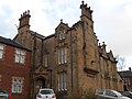
Grade II listed house in Birkenhead, Wirral, Merseyside, England, UK  | |||||
| Upload media | |||||
| Instance of | |||||
|---|---|---|---|---|---|
| Location | Birkenhead, Wirral, Merseyside, North West England, England | ||||
| Heritage designation |
| ||||
 | |||||
Grade II listed house, 1843, since subdivided, the major part now being a rest home.
Media in category "Fearnley, Birkenhead"
The following 4 files are in this category, out of 4 total.
-
 Fearnley, Birkenhead 1.jpg 4,797 × 3,300; 12.6 MB
-
 Fearnley, Birkenhead 2.jpg 4,456 × 3,192; 9.49 MB
-
 Fearnley, Birkenhead 3.jpg 4,431 × 3,431; 10.12 MB
-
 Fearnley, Birkenhead.jpg 4,608 × 3,456; 3.39 MB


