Category:Files from the Massachusetts Department of Environmental Protection
Subcategories
This category has only the following subcategory.
Media in category "Files from the Massachusetts Department of Environmental Protection"
The following 56 files are in this category, out of 56 total.
-
 1 Court Street after power washing, circa 1970s.jpg 2,720 × 4,181; 1.25 MB
-
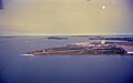
 Aerial view of Allen Harbor.jpg 8,256 × 5,461; 3.23 MB
-
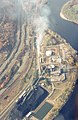
 Aerial view of auto shredder and railroad bridge in Greenfield, 1982.jpg 8,234 × 5,439; 8.73 MB
-
 Aerial view of Brayton Point Power Station (2).jpg 4,106 × 2,719; 963 KB
-
 Aerial view of Brayton Point Power Station.jpg 8,191 × 5,440; 7.53 MB
-
 Aerial view of Commonwealth Avenue, 1980s.jpg 2,677 × 4,170; 1.04 MB
-
 Aerial view of downtown Boston from the south, June 1993.jpg 4,320 × 2,773; 1.56 MB
-
 Aerial view of Fairmount Line at Talbot Avenue, June 1993.jpg 4,416 × 2,741; 1.75 MB
-
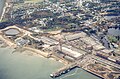
 Aerial view of Fall River.jpg 8,191 × 5,439; 8.61 MB
-
 Aerial view of Fitchburg State College, circa 1980.jpg 8,234 × 5,440; 11.59 MB
-
 Aerial view of Fitchburg, circa 1980.jpg 8,234 × 5,439; 11.18 MB
-
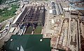
 Aerial view of Fore River Shipyard (1), June 1993.jpg 4,416 × 2,773; 1.47 MB
-
 Aerial view of Fore River Shipyard (2), June 1993.jpg 4,415 × 2,730; 1.61 MB
-
 Aerial view of Fore River Shipyard (3), June 1993.jpg 4,405 × 2,730; 1.42 MB
-
 Aerial view of Fore River Shipyard (4), June 1993.jpg 4,426 × 2,730; 1.52 MB
-
 Aerial view of Fore River Shipyard (5), June 1993.jpg 2,741 × 4,426; 1.92 MB
-
 Aerial view of Framingham, December 1985.jpg 3,664 × 2,448; 2.92 MB
-
 Aerial view of Marina Bay, September 1993.jpg 4,415 × 2,752; 1.11 MB
-
 Aerial view of Morrissey Boulevard and UMass Boston, September 1993.jpg 4,415 × 2,752; 1.14 MB
-
 Aerial view of Mount Tom power plant, circa 1970s.jpg 2,688 × 4,149; 1.35 MB
-
 Aerial view of New Bedford Harbor (1), June 1988.jpg 4,106 × 2,570; 1.08 MB
-
 Aerial view of New Bedford Harbor (2), June 1988.jpg 4,106 × 2,570; 1.13 MB
-
 Aerial view of Plymouth Cordage Company, October 1982.jpg 8,192 × 5,418; 4.26 MB
-
 Aerial view of South Boston, June 1993.jpg 4,426 × 2,741; 1.53 MB
-
 Aerial view of UMass Boston campus, September 1993.jpg 4,426 × 2,752; 1.18 MB
-
 Air quality sampling on Dudley station roof, 1966.jpg 4,053 × 2,751; 1.6 MB
-
 Aquarium station headhouse, circa 1986.jpg 918 × 755; 241 KB
-
 Causeways on East Brimfield Lake, June 2011.jpg 707 × 514; 114 KB
-
 Chelsea tank farm from Orient Heights, circa 1970s.jpg 4,117 × 2,719; 1.5 MB
-
 Commonwealth Avenue south of Washington Street, circa 1970s.jpg 2,709 × 4,042; 1.17 MB
-
 Construction at Logan Airport, circa 1970s.jpg 4,127 × 2,741; 1 MB
-
 Cyclist on Comm Ave in Brighton, circa 1970s.jpg 4,274 × 2,570; 1.02 MB
-
 Early MBTA monthly pass.jpg 1,542 × 1,020; 450 KB
-
 East Fitchburg Yard, February 2007.jpg 2,816 × 2,112; 1.3 MB
-
 Entrance to Wellington station, circa 1970s.jpg 4,106 × 2,719; 915 KB
-
 I-93 northbound in Somerville, circa 1970s.jpg 4,106 × 2,730; 1.03 MB
-
 I-93 southbound in Somerville, circa 1970s.jpg 4,106 × 2,730; 981 KB
-
 I-93 southbound near Mass Ave, circa 1970s.jpg 4,181 × 2,773; 1.26 MB
-
 Interstate 95 northbound in Waltham, circa 1980s.jpg 2,720 × 4,138; 1.02 MB
-
 Jamaicaway bridge from the east, circa 1980s.jpg 4,127 × 2,752; 901 KB
-
 Leverett Circle on-ramp, circa 1970s.jpg 4,106 × 2,602; 967 KB
-
 Long Wharf Marriott, circa 1986.jpg 3,875 × 2,680; 2.28 MB
-
 Looking north along the Central Artery, circa 1970s.jpg 4,138 × 2,752; 1.18 MB
-
 Lower deck of Northern Expressway viaduct, circa 1970s.jpg 4,138 × 2,570; 891 KB
-
 MBTA 5039 at Wellington station, 1970s.jpg 4,106 × 2,720; 1.07 MB
-
 MBTA buses at Watertown Yard, circa 1970s.jpg 4,042 × 2,719; 1.22 MB
-
 Mystic Generating Station, circa 1970s.jpg 2,709 × 4,149; 1.41 MB
-
 Northbound deck of the Charlestown High Bridge, circa 1980s.jpg 4,106 × 2,730; 941 KB
-
 Pan Am freight train on Mystic River bridge, July 2018.jpg 3,935 × 2,120; 2.39 MB
-
 Parking at Woodland station, circa 1970s.jpg 4,229 × 2,863; 2.77 MB
-
 Quincy RMV branch, circa 1980s.jpg 4,095 × 2,741; 978 KB
-
 Red Line train on the Longfellow Bridge, circa 1970s.jpg 4,106 × 2,741; 1.06 MB
-
 Red Line train on the Longfellow Bridge, early 1990s.jpg 4,095 × 2,741; 1,017 KB
-
 Route 2 and Boston skyline, circa 1970s.jpg 4,106 × 2,741; 1.1 MB
-
 Sign for the Lake Street exit on eastbound Route 2, circa 1980s.jpg 4,117 × 2,720; 1.41 MB
-
 Southbound traffic on I-93 approaching Boston, circa 1970s.jpg 4,127 × 2,570; 927 KB


.jpg)


,_June_1993.jpg)
,_June_1993.jpg)
,_June_1993.jpg)
,_June_1993.jpg)
,_June_1993.jpg)


,_June_1988.jpg)
,_June_1988.jpg)


