Category:Fliegerhorst Fürstenfeldbruck
This is the category of the Bavarian Baudenkmal (cultural heritage monument) with the ID D-1-79-121-94 (Wikidata)
|
Former German Air Force military airfield   | |||||
| Upload media | |||||
| Instance of |
| ||||
|---|---|---|---|---|---|
| Location |
| ||||
| Street address |
| ||||
| Architect | |||||
| Operator | |||||
| Has part(s) |
| ||||
| Heritage designation | |||||
| Date of official opening |
| ||||
| End time |
| ||||
| Elevation above sea level |
| ||||
| IATA airport code |
| ||||
| ICAO airport code |
| ||||
 | |||||
Subcategories
This category has the following 2 subcategories, out of 2 total.
1
O
Media in category "Fliegerhorst Fürstenfeldbruck"
The following 76 files are in this category, out of 76 total.
-
 "Gina" in Fursty.jpg 2,441 × 1,557; 834 KB
-
 22d Fighter Squadron - Lockheed P-80B-1-LO Shooting Star - 45-8634.jpg 1,241 × 741; 157 KB
-

-
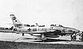
 36th Fighter-Bomber Wing F-84E 49-2150 Furstenfeldbruck AB 1950.jpg 1,607 × 854; 297 KB
-
 AT-6Foak46 (4408481701).jpg 900 × 470; 98 KB
-
 Berg-f84.jpg 600 × 464; 71 KB
-
 Boeing C-97G Stratofreighter des SAC der USAF in Fürstenfeldbruck, 1966 (1a).jpg 4,912 × 3,146; 1.28 MB
-
 Boeing C-97G Stratofreighter des SAC der USAF in Fürstenfeldbruck, 1966 (1b).jpg 4,912 × 2,629; 1.07 MB
-
 COA FFS B.svg 512 × 471; 3 KB
-
 COA WaSLw 50.svg 512 × 623; 10 KB
-
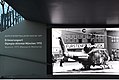 Erinnerungsort Olympia Attentat.jpg 5,944 × 3,984; 4.67 MB
-
 F-80b-49-1007-36fw-skyblazer-1951-Furstenfeldbruck.jpg 600 × 394; 56 KB
-
 Fiat G.91 R3 (DH+120) des JaboG 42 Pferdsfeld, in FFB 1967 (2).jpg 2,441 × 1,533; 534 KB
-
 Fliegerhorst FFB.jpg 3,648 × 2,736; 1.78 MB
-
 Furstenfeldbruck Base Headquarters (4691119729).jpg 2,560 × 1,920; 822 KB
-
 Fursty bei Nacht.jpg 4,710 × 2,742; 727 KB
-
 Fursty GCA - Unit.jpg 2,425 × 1,530; 745 KB
-
 Fursty GCA 1.jpg 2,372 × 1,492; 859 KB
-
 Fursty GCA 10.jpg 1,599 × 2,470; 698 KB
-
 Fursty GCA 11.jpg 1,573 × 2,456; 989 KB
-
 Fursty GCA 2.jpg 2,271 × 1,515; 707 KB
-
 Fursty GCA 3.jpg 3,287 × 3,287; 1.06 MB
-
 Fursty GCA 4.jpg 1,708 × 2,578; 1,012 KB
-
 Fursty GCA 5.jpg 3,142 × 3,646; 533 KB
-
 Fursty GCA 6.jpg 1,548 × 2,141; 442 KB
-
 Fursty GCA 7.jpg 2,410 × 1,587; 938 KB
-
 Fursty GCA 8.jpg 3,202 × 1,960; 812 KB
-
 Fursty GCA 9.jpg 1,602 × 2,393; 941 KB
-
 Fursty Tower + Feuerwehr.jpg 2,404 × 1,473; 746 KB
-
 Fursty Tower mit "Museum".jpg 2,456 × 1,573; 1.08 MB
-
 FWP149-9134 (14172798783).jpg 1,200 × 780; 357 KB
-
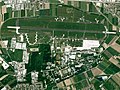 Fürstenfeldbruck Airfield Aerial.jpg 913 × 684; 237 KB
-
 Germany 1955 (4691129667).jpg 2,560 × 1,920; 474 KB
-
 Germany 1955 (4691131759) A1.jpg 2,560 × 1,394; 502 KB
-
 Germany 1955 (4691131759).jpg 2,560 × 1,920; 577 KB
-
 Gernlinden - Blick auf Fliegerhorst - geo.hlipp.de - 25963.jpg 640 × 480; 65 KB
-
 IAF Memory for the Future Flyby 3.jpg 2,000 × 1,487; 704 KB
-
 IFR Raum Fursty 2.jpg 3,269 × 2,193; 1.51 MB
-
 IFR Raum, Fursty 4-2.jpg 3,269 × 2,193; 1.95 MB
-
 IFR Raum, Fursty 7-1.jpg 3,269 × 2,193; 1.48 MB
-
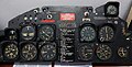 Instrumentenbrett, T - 33 A-1.jpg 5,212 × 2,653; 3.53 MB
-
 Lockheed P-80A color (5042928527).jpg 1,112 × 727; 225 KB
-
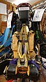 Martin Baker Schleudersitz MK GU 5.jpg 3,080 × 5,472; 3.92 MB
-
 RCAF Shooting Star in Fursty.jpg 2,380 × 1,485; 1.12 MB
-
-
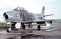 Sabre in Fursty.jpg 2,410 × 1,539; 1.06 MB
-
 Shooting Star in Fursty 1.jpg 2,396 × 1,572; 520 KB
-
 Shooting Star in Fursty 2 (V).jpg 2,942 × 1,262; 560 KB
-
 Shooting Star in Fursty 2.jpg 2,942 × 1,897; 1.24 MB
-
 Shooting Star in Fursty 3.jpg 2,672 × 1,751; 1.43 MB
-
 Skytrain in Fursty (Bildausschnitt).jpg 2,370 × 1,118; 385 KB
-
 Skytrain in Fursty.jpg 2,370 × 1,537; 604 KB
-
 Starfighter in Fursty 1.jpg 2,370 × 1,578; 813 KB
-
 Starfighter in Fursty 2.jpg 2,320 × 1,533; 725 KB
-
 Stratofreighter in Fursty 1.jpg 2,453 × 1,605; 859 KB
-
 Stratofreighter in Fursty 2.jpg 4,912 × 3,146; 1.26 MB
-
 Stratofreighter in Fursty 3.jpg 2,456 × 1,573; 475 KB
-
 T - 33 Take-off in Fursty.jpg 3,424 × 2,230; 1.07 MB
-
 T- 33 Formation Take-off in Fursty.jpg 3,728 × 2,466; 969 KB
-
 T-33 Ausbildungsflug 1.1.jpg 3,188 × 2,094; 1.04 MB
-
 T-33 Ausbildungsflug 1a.jpg 2,432 × 1,593; 1.18 MB
-
 T-33 Ausbildungsflug 1b.jpg 2,446 × 1,611; 919 KB
-
 T-33 Ausbildungsflug 1c.jpg 2,468 × 1,606; 1.34 MB
-
 T-33 Ausbildungsflug 1d.jpg 2,449 × 1,596; 560 KB
-
 T-33 Ausbildungsflug 2a.jpg 4,109 × 2,676; 1.49 MB
-
 T-33 Ausbildungsflug 2b.jpg 2,488 × 1,623; 905 KB
-
 T-33 Ausbildungsflug 2c.jpg 2,468 × 1,606; 1.32 MB
-
 T-33 Ausbildungsflug 2d.jpg 2,471 × 1,613; 1.37 MB
-
 T-33 Ausbildungsflug 2e.jpg 2,425 × 1,612; 1.37 MB
-
 T-33 Ausbildungsflug 2f.jpg 1,616 × 1,316; 462 KB
-
 T-33 Ausbildungsflug 2g.jpg 2,343 × 1,676; 1.3 MB
-
 T-33 Ausbildungsflug 2h.jpg 2,455 × 1,612; 1.35 MB
-
 T-33 Ausbildungsflug 2i.jpg 2,452 × 1,599; 1.33 MB
-
 T-33 Ausbildungsflug 3a.jpg 2,964 × 1,919; 1.05 MB
-
 T-33 Ausbildungsflug 3b.jpg 1,487 × 1,761; 1.39 MB
-
 Thunderchief in Fursty.jpg 2,354 × 1,461; 1.05 MB


.jpg)

.jpg)
.jpg)


_des_JaboG_42_Pferdsfeld,_in_FFB_1967_(2).jpg)
.jpg)


.jpg)
.jpg)
_A1.jpg)
.jpg)


.jpg)


.jpg)


.jpg)


.jpg)


