Category:Flore, Northamptonshire
English: Flore is a village and civil parish in the West Northamptonshire district of the county of Northamptonshire in England. The A45 road divides the upper part of the village from several older, lower streets. The population at the 2001 census was 1,221.
village and civil parish in Northamptonshire, England, UK  | |||||
| Upload media | |||||
| Instance of | |||||
|---|---|---|---|---|---|
| Location | West Northamptonshire, Northamptonshire, East Midlands, England | ||||
| Population |
| ||||
| Area |
| ||||
 | |||||
Subcategories
This category has the following 2 subcategories, out of 2 total.
Media in category "Flore, Northamptonshire"
The following 117 files are in this category, out of 117 total.
-
 Brockhall Road - geograph.org.uk - 2490590.jpg 640 × 480; 108 KB
-
 Brockhall Road - geograph.org.uk - 2490598.jpg 640 × 480; 65 KB
-
 Brockhall Road bridge - geograph.org.uk - 2490578.jpg 640 × 480; 63 KB
-
 Brockhall Road bridge over the M1 - geograph.org.uk - 4318917.jpg 640 × 379; 82 KB
-

-
 Brockhall Road crossing the M1 motorway - geograph.org.uk - 4734141.jpg 800 × 563; 110 KB
-
 Canal Boats - geograph.org.uk - 983070.jpg 640 × 480; 56 KB
-
 Country lane north of M1 - geograph.org.uk - 3823055.jpg 640 × 480; 44 KB
-
 Entrance to Flore - geograph.org.uk - 3823051.jpg 640 × 451; 51 KB
-
 Farm buildings north of the M1 Motorway - geograph.org.uk - 4734151.jpg 800 × 600; 157 KB
-

-
 Farmland near Brockhall - geograph.org.uk - 1735373.jpg 640 × 427; 77 KB
-
 Farmland near Flore - geograph.org.uk - 1855379.jpg 640 × 480; 66 KB
-

-
 Fingerpost along Brockhall Road - geograph.org.uk - 4734163.jpg 800 × 600; 156 KB
-
 Flore village flag.svg 430 × 258; 12 KB
-
 Flore - geograph.org.uk - 270418.jpg 640 × 480; 103 KB
-
 Flore - geograph.org.uk - 270445.jpg 640 × 480; 101 KB
-
 Flore - geograph.org.uk - 270452.jpg 640 × 480; 123 KB
-
 Flore - geograph.org.uk - 91914.jpg 640 × 480; 134 KB
-
 Flore Bends - geograph.org.uk - 1213626.jpg 640 × 427; 76 KB
-
 Flore Fields - geograph.org.uk - 1956746.jpg 640 × 480; 66 KB
-
 Flore Fields Lodge - geograph.org.uk - 1735362.jpg 640 × 427; 91 KB
-
 Flore Fields-Butlin's Farm - geograph.org.uk - 1732247.jpg 800 × 543; 113 KB
-
 Flore Firework Display - geograph.org.uk - 1574674.jpg 640 × 637; 138 KB
-
 Flore Firework Display - geograph.org.uk - 1574680.jpg 451 × 640; 62 KB
-
 Flore Footpath - geograph.org.uk - 1734227.jpg 640 × 480; 127 KB
-
 Flore House - geograph.org.uk - 1097895.jpg 427 × 640; 55 KB
-
 Flore House - geograph.org.uk - 1213641.jpg 640 × 427; 77 KB
-
 Flore House along the Avenue in Flore - geograph.org.uk - 4734047.jpg 800 × 544; 176 KB
-
 Flore M1 geograph-3390527-by-Ben-Brooksbank.jpg 2,382 × 1,367; 2.44 MB
-
 Flore Salvation Army Hall - geograph.org.uk - 1734272.jpg 640 × 480; 58 KB
-
 Flore School - geograph.org.uk - 1213934.jpg 640 × 427; 67 KB
-
 Flore Scout Group HQ - geograph.org.uk - 1213965.jpg 640 × 427; 82 KB
-
 Flore village sign along the A45 - geograph.org.uk - 4734087.jpg 800 × 546; 160 KB
-
 Flore, All Saints' Church - geograph.org.uk - 4170341.jpg 1,024 × 768; 179 KB
-
 Flore, kissing gate - geograph.org.uk - 4170177.jpg 1,024 × 768; 170 KB
-
 Flore, kissing gate - geograph.org.uk - 4170364.jpg 1,024 × 768; 133 KB
-
 Flore, Meadow Farmhouse - geograph.org.uk - 4170166.jpg 1,024 × 768; 149 KB
-
 Flore, postbox No. NN7 329 - geograph.org.uk - 1290399.jpg 640 × 480; 61 KB
-
 Flore, Rock Springs - geograph.org.uk - 4170168.jpg 1,024 × 768; 166 KB
-
 Flore, The former Royal Oak - geograph.org.uk - 4555056.jpg 640 × 480; 62 KB
-
 Flore, United Reformed Church - geograph.org.uk - 4170171.jpg 1,024 × 768; 143 KB
-
 Flore, White Hart - geograph.org.uk - 4170173.jpg 1,024 × 768; 115 KB
-
 Flore, White Hart - geograph.org.uk - 4555133.jpg 640 × 480; 53 KB
-
 Flore-Hillside Road - geograph.org.uk - 1732253.jpg 640 × 480; 94 KB
-
 Flore-M1 Motorway - geograph.org.uk - 1734244.jpg 640 × 480; 78 KB
-
 Flore-The Old Chequers Inn - geograph.org.uk - 1734287.jpg 640 × 480; 83 KB
-
 Footpath to Flore Church - geograph.org.uk - 870658.jpg 640 × 425; 121 KB
-
 Glassthorpe DMV, aerial 2019 - geograph.org.uk - 6239669.jpg 800 × 533; 81 KB
-

-
 House along The Avenue in Flore - geograph.org.uk - 4734027.jpg 800 × 600; 175 KB
-
 Lady Marion Loder.jpg 1,246 × 1,568; 233 KB
-
 Lodge along Brockhall Road - geograph.org.uk - 4734156.jpg 800 × 600; 163 KB
-
 Lodge family at Flore House 1931.jpg 1,846 × 2,722; 832 KB
-
 Lodge, Brockhall Road - geograph.org.uk - 2490588.jpg 640 × 464; 129 KB
-
 M1 between Brockhall and Flore - geograph.org.uk - 1736638.jpg 640 × 480; 68 KB
-

-
 M1 Motorway - geograph.org.uk - 2490577.jpg 640 × 480; 92 KB
-

-

-
 M1 motorway at Broamenthill Spinney - geograph.org.uk - 2899395.jpg 640 × 480; 61 KB
-

-
 M1 motorway near Hollandstone Farm - geograph.org.uk - 2899355.jpg 640 × 480; 52 KB
-

-
 M1 near Brockhall - geograph.org.uk - 4317756.jpg 640 × 415; 68 KB
-
 M1 towards London - geograph.org.uk - 4318918.jpg 640 × 348; 64 KB
-
 Macmillan-Nene Way - geograph.org.uk - 2942694.jpg 640 × 480; 97 KB
-
 Marsh Cottage - geograph.org.uk - 2490566.jpg 640 × 480; 72 KB
-
 Massey Ferguson 24 Telehandler - geograph.org.uk - 3419475.jpg 640 × 478; 91 KB
-
 Meadow Farm - geograph.org.uk - 3419477.jpg 640 × 478; 71 KB
-
 North-west from Clarke's garage - geograph.org.uk - 490029.jpg 640 × 477; 96 KB
-
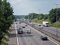
 Northbound M1 near to Flore - geograph.org.uk - 6264026.jpg 800 × 533; 513 KB
-
 Over the fields and far away - geograph.org.uk - 1172975.jpg 640 × 480; 61 KB
-
 Overbridge, M1, southbound - geograph.org.uk - 4694872.jpg 640 × 402; 46 KB
-
 Path towards the M1 - geograph.org.uk - 489380.jpg 640 × 477; 149 KB
-
 Pet Crematorium - geograph.org.uk - 1855384.jpg 640 × 480; 87 KB
-
 Road to Brockhall - geograph.org.uk - 1735379.jpg 640 × 427; 74 KB
-
 Sale notice Flore House 1924.jpg 1,268 × 1,666; 284 KB
-
 Sears Close - geograph.org.uk - 1855391.jpg 640 × 480; 64 KB
-
 Setting Sun - geograph.org.uk - 983080.jpg 480 × 640; 39 KB
-
 Sign Gantry across the M1 - geograph.org.uk - 6264029.jpg 800 × 533; 506 KB
-
 Sir Edmund Loder.jpg 1,200 × 1,641; 198 KB
-
 South of Vicarage Farm - geograph.org.uk - 489355.jpg 640 × 477; 81 KB
-
 Stile and footbridge - geograph.org.uk - 489340.jpg 640 × 477; 105 KB
-
 Sutton Street, Flore - geograph.org.uk - 489983.jpg 640 × 477; 60 KB
-
 The Avenue - geograph.org.uk - 1213637.jpg 427 × 640; 70 KB
-
 The Avenue - geograph.org.uk - 5072846.jpg 4,000 × 3,000; 3.04 MB
-
 The Avenue heading towards Flore - geograph.org.uk - 4734004.jpg 800 × 580; 156 KB
-
 The Avenue in the village of Flore - geograph.org.uk - 4734039.jpg 800 × 596; 177 KB
-

-
 The Old Rectory, Flore - geograph.org.uk - 489990.jpg 640 × 477; 107 KB
-
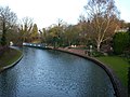
 The River Nene at Flore - geograph.org.uk - 798819.jpg 640 × 480; 130 KB
-
 The welcoming party - geograph.org.uk - 489368.jpg 640 × 477; 119 KB
-
 The White Hart - geograph.org.uk - 5890739.jpg 640 × 480; 85 KB
-
 Tractor and trailer on Brockhall Road - geograph.org.uk - 4734125.jpg 800 × 635; 204 KB
-
 United Reformed Church, Flore - geograph.org.uk - 1172953.jpg 640 × 480; 82 KB
-
 United Reformed Meeting House, Flore. - geograph.org.uk - 1172959.jpg 480 × 640; 133 KB
-
 Water Tower, Flore Hill - geograph.org.uk - 199756.jpg 480 × 640; 63 KB
-
 Wheat field Brockhall Road - geograph.org.uk - 2490583.jpg 640 × 480; 106 KB
-
 Wheat field near Butlin's Farm - geograph.org.uk - 2490593.jpg 640 × 480; 103 KB
-
 White Hart pub along the A45 in Flore - geograph.org.uk - 4734101.jpg 800 × 548; 133 KB
-
 A clear track - geograph.org.uk - 489373.jpg 640 × 477; 108 KB
-
 Apple blossom - geograph.org.uk - 489351.jpg 477 × 640; 165 KB
-
 Approaching Clarke's garage - geograph.org.uk - 490012.jpg 640 × 477; 92 KB
-
 Barn and feed silo by the M1 - geograph.org.uk - 490088.jpg 640 × 480; 80 KB
-
 Crossing the River Nene - geograph.org.uk - 490007.jpg 640 × 477; 115 KB
-

-
 Dovecot in Flore - geograph.org.uk - 489988.jpg 640 × 477; 103 KB
-
 Fishermen near Vicarage Farm - geograph.org.uk - 489361.jpg 640 × 477; 77 KB
-
 Flore - geograph.org.uk - 91916.jpg 640 × 480; 96 KB
-
 Footpath from Flore - geograph.org.uk - 489979.jpg 640 × 477; 138 KB
-
 Horse mounting box or stile^ - geograph.org.uk - 489973.jpg 640 × 477; 103 KB
-
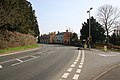
 Junction of A5 and A45 - geograph.org.uk - 33757.jpg 640 × 480; 91 KB
-
 M1 north towards Leeds - geograph.org.uk - 489861.jpg 640 × 480; 72 KB
-
 M1 towards London - geograph.org.uk - 489858.jpg 640 × 480; 87 KB
-
 Macmillan Way across farmland - geograph.org.uk - 489363.jpg 477 × 640; 109 KB


,_Weedon_Bec_-_geograph.org.uk_-_454962.jpg)


