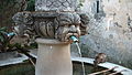
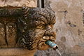
Category:Fontaine des Mascarons (Séguret)
| Object location | | View all coordinates using: OpenStreetMap |
|---|
| Object location | | View all coordinates using: OpenStreetMap |
|---|
|
This building is classé au titre des monuments historiques de la France. It is indexed in the base Mérimée, a database of architectural heritage maintained by the French Ministry of Culture, under the reference PA00082164
|
 | |||||
| Upload media | |||||
| Instance of | |||||
|---|---|---|---|---|---|
| Location | Séguret, Vaucluse, Provence-Alpes-Côte d'Azur, Metropolitan France, France | ||||
| Heritage designation |
| ||||
 | |||||
Media in category "Fontaine des Mascarons (Séguret)"
The following 12 files are in this category, out of 12 total.
-
 Fontaine des Mascarons up close, Séguret.jpg 4,896 × 2,752; 7.56 MB
-
 Fontaine des Mascarons, Séguret.jpg 3,804 × 2,564; 7.53 MB
-
 Fontaine des Mascarons.jpg 2,637 × 3,517; 2.98 MB
-
 Fontaine des Mascarrons.jpg 1,872 × 1,040; 444 KB
-
 Seguret3.jpg 2,880 × 1,620; 1.34 MB
-
 Séguret - fontaine des mascarons 1.jpg 3,000 × 4,000; 3.38 MB
-
 Séguret - fontaine des mascarons 2.jpg 3,000 × 4,000; 2.68 MB
-
 Séguret - fontaine des mascarons 3.jpg 3,000 × 4,000; 3.54 MB
-
 Séguret - fontaine des mascarons 4.jpg 4,000 × 3,000; 2.74 MB
-
 Séguret - fontaine des mascarons 5.jpg 3,000 × 4,000; 2.43 MB
-
 Séguret fontaine.JPG 3,888 × 2,592; 4.73 MB
-


.jpg)