Category:Fort Sint Anthonie ('s-Hertogenbosch)
| Object location | | View all coordinates using: OpenStreetMap |
|---|
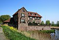
house in 's-Hertogenbosch, Netherlands  | |||||
| Upload media | |||||
| Instance of | |||||
|---|---|---|---|---|---|
| Location | 's-Hertogenbosch, North Brabant, Netherlands | ||||
| Street address |
| ||||
| Architectural style | |||||
| Architect | |||||
| Heritage designation |
| ||||
| Inception |
| ||||
 | |||||
|
This is a category about rijksmonument number 522525
|
| Address |
|
Media in category "Fort Sint Anthonie ('s-Hertogenbosch)"
The following 5 files are in this category, out of 5 total.
-
 2015.02.16.132429 House Vughterweg 's-Hertogenbosch.jpg 2,736 × 1,824; 1.57 MB
-
 2015.02.16.132445 House Vughterweg 's-Hertogenbosch.jpg 2,736 × 1,824; 1.51 MB
-
 522525 Fort Sint Anthonie (2).jpg 4,570 × 2,000; 7.45 MB
-
 522525 Fort Sint Anthonie.jpg 2,667 × 4,000; 8.94 MB
-
 Vughterweg 74.jpg 3,379 × 2,304; 3.18 MB


.jpg)
