Category:Forteviot
village in Perth and Kinross, Scotland, UK  | |||||
| Upload media | |||||
| Instance of | |||||
|---|---|---|---|---|---|
| Location |
| ||||
 | |||||
English: Forteviot is a village in Strathearn, Scotland on the south bank of the River Earn between Dunning and Perth. It lies in the council area of Perth and Kinross. The population in 1991 was 160.
Gàidhlig: 'S e baile-beag ann am Peairt agus Ceann Rois a th' ann am Fothair Tabhaicht (Beurla: Forteviot). 'S e seo na co-chomharran aige: 56° 20′ 25.19″ ″ Tuath agus 3° 32′ 6.5″ Iar.

Media in category "Forteviot"
The following 47 files are in this category, out of 47 total.
-
 A fine show of heathers at The Farl - geograph.org.uk - 1212785.jpg 640 × 456; 94 KB
-
 B934 looking to Broomhill - geograph.org.uk - 52811.jpg 640 × 437; 81 KB
-
 Dog rose at the roadside - geograph.org.uk - 194321.jpg 640 × 488; 151 KB
-
 Farmland - geograph.org.uk - 194322.jpg 640 × 480; 51 KB
-
 Farmland near to Forteviot - geograph.org.uk - 834057.jpg 640 × 426; 47 KB
-
 Ferns - geograph.org.uk - 694782.jpg 640 × 480; 126 KB
-
 Forteviot - geograph.org.uk - 477452.jpg 640 × 428; 288 KB
-
 Forteviot - geograph.org.uk - 477454.jpg 640 × 423; 290 KB
-
 Forteviot - panoramio.jpg 6,016 × 4,000; 13.73 MB
-
 Forteviot Bridge - geograph.org.uk - 288148.jpg 640 × 480; 184 KB
-
 Forteviot Bridge - geograph.org.uk - 691262.jpg 640 × 480; 99 KB
-
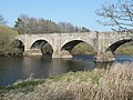 Forteviot Bridge over River Earn - geograph.org.uk - 1212757.jpg 640 × 480; 104 KB
-
 Forteviot Parish Church.JPG 3,088 × 2,056; 1.55 MB
-
 Forteviot Village Hall.JPG 3,088 × 2,056; 1.52 MB
-
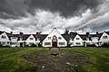
 Main Square, Forteviot.jpg 640 × 282; 177 KB
-
 Removed railings, Dupplin Castle - geograph.org.uk - 691265.jpg 640 × 480; 130 KB
-
 River Earn at Forteviot Bridge - geograph.org.uk - 25294.jpg 640 × 485; 196 KB
-
 River Earn at Forteviot.jpg 640 × 480; 116 KB
-
 Swans below Forteviot Bridge - geograph.org.uk - 1212764.jpg 480 × 640; 117 KB
-
 Waiting for the harvest - geograph.org.uk - 194318.jpg 640 × 480; 102 KB
-
 Water of May - geograph.org.uk - 691246.jpg 640 × 480; 124 KB
-
 Arable land, Henhill - geograph.org.uk - 682889.jpg 640 × 480; 111 KB
-
 Bend and cottage on old A9 - geograph.org.uk - 369055.jpg 640 × 480; 122 KB
-
 Berries and fields - geograph.org.uk - 288735.jpg 640 × 481; 180 KB
-
 Bogtonlea - geograph.org.uk - 691391.jpg 640 × 480; 87 KB
-
 Bridge over Perth - Glasgow line - geograph.org.uk - 369047.jpg 640 × 480; 158 KB
-
 Derelict Lodges - geograph.org.uk - 288159.jpg 640 × 483; 211 KB
-
 Earn flood plain - geograph.org.uk - 691263.jpg 640 × 480; 73 KB
-
 Entrance to Wester Clevage - geograph.org.uk - 288140.jpg 640 × 481; 152 KB
-
 Farmland and the Edge of Cairnie Wood - geograph.org.uk - 730325.jpg 640 × 425; 180 KB
-
 Fields in December - geograph.org.uk - 288132.jpg 640 × 480; 163 KB
-
 Forest clearing - geograph.org.uk - 694893.jpg 640 × 482; 172 KB
-
 Forest on Gask Ridge - geograph.org.uk - 694880.jpg 640 × 482; 189 KB
-
 Henhill - geograph.org.uk - 691249.jpg 640 × 480; 96 KB
-
 Hog's Wood - geograph.org.uk - 691382.jpg 480 × 640; 110 KB
-
 Innerdunning - geograph.org.uk - 369057.jpg 640 × 480; 103 KB
-
 Kildinny Farm - geograph.org.uk - 369045.jpg 640 × 480; 142 KB
-
 Level Crossing - geograph.org.uk - 25300.jpg 640 × 480; 133 KB
-

-
 Upper Cairnie - geograph.org.uk - 369053.jpg 640 × 480; 88 KB
-
 Water of May - geograph.org.uk - 288163.jpg 640 × 480; 211 KB
-
 West Lodge, Invermay - geograph.org.uk - 691387.jpg 640 × 480; 122 KB
-
 Wind break at Wester Cairnie - geograph.org.uk - 369052.jpg 640 × 480; 124 KB
-
 Winter crops, Invermay - geograph.org.uk - 691248.jpg 640 × 480; 64 KB
-
 Woodland, Dupplin - geograph.org.uk - 682909.jpg 640 × 480; 80 KB
-
 Woodland, Dupplin - geograph.org.uk - 691264.jpg 640 × 480; 139 KB
-
 Woodland, Invermay - geograph.org.uk - 691242.jpg 640 × 480; 139 KB


