Category:Franciscan Complex
Subcategories
This category has the following 14 subcategories, out of 14 total.
*
+
- Franciscan Complex - maps (2 F)
.
B
- Boggs Mountain (2 F)
F
L
- Lompoc Oil Field (5 F)
P
- Paleobiota of the Franciscan Complex (empty)
Media in category "Franciscan Complex"
The following 19 files are in this category, out of 19 total.
-
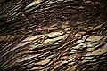
 Blue folded metacherts with glaucophane-rich (ashy?) layers.jpg 5,472 × 3,648; 7.98 MB
-

-

-

-
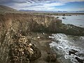 Franciscan melange + radiolarite, Estero Bluffs SP, just N of Cayucos, CA (50757250907).jpg 3,751 × 2,812; 3.69 MB
-
 Franciscan subduction model.gif 640 × 365; 35 KB
-
 Garnetiferous blueschist (Ward Creek, Sonoma County, California, USA) 3.jpg 2,826 × 2,284; 4.89 MB
-
 Glaucophane-lawsonite blueschist, Marin County CA.jpg 3,408 × 2,360; 1.82 MB
-
 Glaucophanite Blueschist from Marin County California.jpg 3,072 × 2,872; 2.69 MB
-
 Glen Canyon Park Chert Outcrop.jpg 2,504 × 2,008; 2.17 MB
-
 LompocOilFieldStructureMap.jpg 5,312 × 2,988; 4.18 MB
-
 Marin Headlands ribbon chert.jpg 4,500 × 3,004; 7 MB
-

-
 Radiolarian chert, San Simeon state park.jpg 3,264 × 2,448; 5.4 MB
-
 Ribbon chert of the Marin Headlands Terrane, exposed at Marshall's Beach, San Francisco.jpg 5,472 × 3,648; 7.82 MB
-
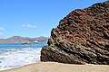
 Same cove. Clear water! North coast, SLO county. (50005836958).jpg 3,024 × 3,851; 4.77 MB
-
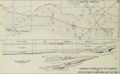 SantaMariaValleyOilFieldStructureMap.png 986 × 607; 424 KB
-

-
 Sheared Serpentinite.jpg 5,472 × 3,648; 11.27 MB
_layers.jpg)
_1_(15098363282).jpg)
_2_(25400412690).jpg)
_(25608538391).jpg)
.jpg)

_3.jpg)


_16_(46348427475).jpg)


.jpg)