Category:Franziskanerstraße B 219 (Neuburg an der Donau)
This is the category of the Bavarian Baudenkmal (cultural heritage monument) with the ID D-1-85-149-90 (Wikidata)
|
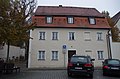
Deutsch: Friedhofsverwaltung. Zweigeschossiger freistehender Mansarddachbau, 1827
.
Franziskanerstraße B 219, Neuburg an der Donau, Bayern, Deutschland
Franziskanerstraße B 219, Neuburg an der Donau, Bayern, Deutschland
| Object location | | View all coordinates using: OpenStreetMap |
|---|
.JPG) | |||||
| Upload media | |||||
| Instance of | |||||
|---|---|---|---|---|---|
| Location | Neuburg an der Donau, Neuburg-Schrobenhausen, Upper Bavaria, Bavaria, Germany | ||||
| Street address |
| ||||
| Heritage designation | |||||
 | |||||
Media in category "Franziskanerstraße B 219 (Neuburg an der Donau)"
The following 4 files are in this category, out of 4 total.
-
 Fanziskanerstraße B 219 2016 (01).jpg 4,928 × 3,264; 7.08 MB
-
 Franziskanerstraße B 219 (Neuburg a. d. Donau).JPG 2,304 × 1,728; 1.39 MB
-
 Franziskanerstraße B 219 2016 (02).jpg 4,928 × 3,264; 6.99 MB
-
 Franziskanerstraße B 219 2016 (03).jpg 4,928 × 3,264; 7.07 MB
.jpg)
.jpg)
.jpg)