Category:Freiligrath-Denkmal (Rolandswerth)
| Object location | | View all coordinates using: OpenStreetMap |
|---|
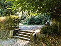
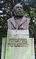
memorial in Rolandswerth, Germany  | |||||
| Upload media | |||||
| Instance of | |||||
|---|---|---|---|---|---|
| Commemorates | |||||
| Made from material | |||||
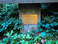
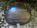
| Location | Remagen, Ahrweiler, Rhineland-Palatinate, Germany | ||||
 | |||||
Media in category "Freiligrath-Denkmal (Rolandswerth)"
The following 10 files are in this category, out of 10 total.
-
 2018-09-27-remagen-rolandsbogen-freiligrath-denkmal-01.jpg 4,000 × 3,000; 2.09 MB
-
 2018-09-27-remagen-rolandsbogen-freiligrath-denkmal-02.jpg 4,000 × 3,000; 1.78 MB
-
 2018-09-27-remagen-rolandsbogen-freiligrath-denkmal-03.jpg 4,000 × 3,000; 1.62 MB
-
 2018-09-27-remagen-rolandsbogen-freiligrath-denkmal-04.jpg 4,000 × 3,000; 2.69 MB
-
 2018-09-27-remagen-rolandsbogen-freiligrath-denkmal-05.jpg 4,000 × 3,000; 1.46 MB
-
 2018-09-27-remagen-rolandsbogen-freiligrath-denkmal-06.jpg 4,000 × 3,000; 1.44 MB
-
 2018-09-27-remagen-rolandsbogen-freiligrath-denkmal-07.jpg 3,000 × 4,000; 706 KB
-
 2018-09-27-remagen-rolandsbogen-freiligrath-denkmal-08.jpg 4,000 × 3,000; 1.91 MB
-
 Freiligrath-Denkmal.jpg 732 × 1,184; 122 KB
-
 Freiligrath-Denkmal.JPG 1,920 × 2,560; 1.3 MB


