Category:Gärbihof, Dürrenroth
| Object location | | View all coordinates using: OpenStreetMap |
|---|
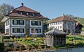
ensemble of buildings as a farmstead in Dürrenroth in the canton of Bern, Switzerland  | |||||
| Upload media | |||||
| Instance of | |||||
|---|---|---|---|---|---|
| Part of | |||||
| Location | Dürrenroth, Emmental administrative district, Emmental-Oberaargau administrative region, Bern, Switzerland | ||||
| Street address |
| ||||
| Heritage designation | |||||
| Inception |
| ||||
 | |||||
Media in category "Gärbihof, Dürrenroth"
The following 2 files are in this category, out of 2 total.
-
 Dürrenroth - Gärbihof 7 & 9.jpg 3,840 × 2,400; 6.62 MB
-
 Gärbihof.jpg 2,065 × 1,720; 1.37 MB
